 Nelson 1880s

|

|
|
|
item:- JandMN (474_2) image:- © see bottom of page |
click to enlarge |
|
|
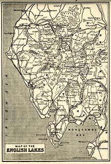
Map, uncoloured lithograph, Map of the English Lakes,
published by Thomas Nelson and Sons, London, 1880s?
The included railways suggest a date in the 1880s. Opposite p.7 of Views of the English Lakes, and Tourists Guide to the English Lakes. |
||

|
Nelson 1880s | |
| map feature:- | plain cartouche & up is N & sea shaded & coast line & rivers & lakes & relief & hill hachuring & spot heights & county & settlements & roads & railways | |
| inscription:- |
printed plain cartouche, lower left
MAP OF THE / ENGLISH LAKES |
|
| wxh, page:- | 9.5x14cm | |
| wxh, image:- | 85x126mm | |