 Moule 1836

|

|
|
|
item:- JandMN (467) image:- © see bottom of page |
click to enlarge |
|
|
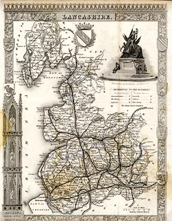
Map, uncoloured engraving, Lancashire, scale about 8.5
miles to 1 inch, by Thomas Moule, published by George
Virtue, Ivy Lane, Paternoster Row, London, 1836, edn about
1846?
Included in Moule's English Counties or The English Counties Delineated. There are coats of arms; a vignette scene shows Nelson's Monument, Liverpool. Numerous railways are shown, in the Cumbria area are - The Lancaster and Carlisle Railway, Kendal and Windermere Railway, and Furness Railway from Broughton to Piel, all clearly engraved over an existing map. |
||

|
Moule 1836 | |
| map feature:- | decorative border & plain cartouche & coat of arms & vignettes & up is N & scale line & sea plain & coast form lines & rivers & lakes & relief & hill hachuring & parks & county & hundreds & table of hundreds & settlements & roads & railways | |
| inscription:- |
printed title cartouche, upper centre
LANCASHIRE. |
|
| inscription:- |
printed with scale line
Scale of Miles |
|
| scale line:- | 10 miles = 30.4 mm | |
| wxh, sheet:- | 21.5x26.5cm | |
| wxh, map (badly trimmed):- | 20x26.5cm | |
| scale:- | 1 to 530000 ? (1 to 529389 from scale line) | |