 Bartholomew 1900s

|

|
|
|
item:- private collection (282) image:- © see bottom of page |
click to enlarge |
|
|
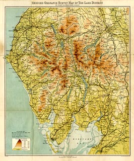
Map, colour lithograph, Travelling Maps series, Reduced
Ordnance Survey Map of The Lake District, scale about 3
miles to 1 inch, by John Bartholomew and Co, Edinburgh,
published by W H Smith and Son, 186 Strand, London, about
1900s.
|
||

|
Bartholomew 1900s | |
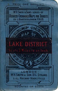
| map feature:- | mounted & folded (4x3) & card cover & table of symbols & up is N & scale line & sea tinted & coast line & foreshore sands & rivers & lakes & relief & layer colouring & spot heights & table of heights & settlements & roads & canals & railways | |
| inscription:- |
printed top
REDUCED ORDNANCE SURVEY MAP OF THE LAKE DISTRICT / BY JOHN BARTHOLOMEW, F.R.G.S. |
|
| inscription:- |
printed bottom right
John Bartholomew & Co., Edinr. |
|
| inscription:- |
printed cover
black on blue, with red on black title label |
|
| inscription:- |
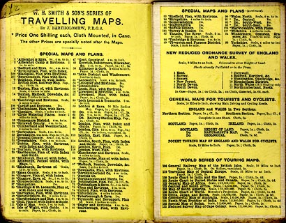
printed advertisement inside front cover
W. H. SMITH & SON'S SERIES OF / TRAVELLING MAPS. / BY JOHN BARTHOLOMEW, F.R.G.S. / ... |
|
| inscription:- |
printed with scale line
SCALE OF 3 MILES TO AN INCH. |
|
| scale line:- | 6 miles = 49.9 mm | |
| wxh, cover:- | 11x17cm | |
| wxh, sheet:- | 39x47.5cm | |
| wxh, map:- | 364x435mm | |
| scale:- | 1 to 190000 ? (1 to 193508 from scale line) | |
|
||
|
||
|
||