 Senex 1719-57

|

|
|
|
item:- private collection (272_4) image:- © see bottom of page |
click to enlarge |
|
|
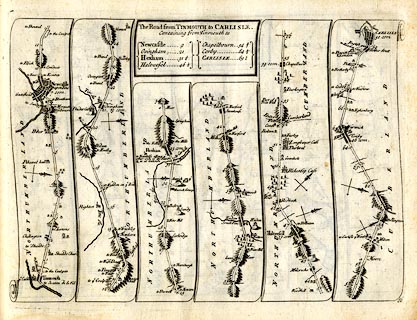
Strip map, road map, The Road from Tinmouth to Carlisle,
including from Haltwhistle, Northumberland; through Brampton
to Carlisle, Cumberland, by John Senex, The Globe, Salisbury
Court, Fleet Street, London, 1719.
Plate 86 in An Actual Survey of all the Principal Roads of England and Wales. |
||

|
Senex 1719-57 | |
| map feature:- | title cartouche & plain cartouche & north point & up is destination & rivers & relief & hillocks & county & settlements & roads & road distances & distances from start | |
| inscription:- |
printed plain cartouche, upper centre
The Road from TINMOUTH to CARLISLE. / Containing from Tinmouth to / Newcastle 9 / Ovingham 21 / Hexham 31 1/2 / Haltwesel 46 1/2 / Chapelbourn 542/3 / Corby 64 1/2 / CARLISLE 69 1/2 |
|
| inscription:- |
printed bottom right
86 |
|
| wxh, sheet:- | 24x19cm | |
| wxh, plate:- | 215x160mm | |
| wxh, map:- | 214x154mm (approx) | |