 Jeffery 1775

|

|
|
|
item:- private collection (271_4) image:- © see bottom of page |
click to enlarge |
|
|
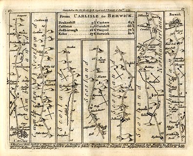
Strip map, road map, From Carlisle to Berwick, including
from Carlisle, Cumberland; into Scotland at Kirshopefoot,
and an itinerary for Carlisle to Glasgow, by Thomas
Jefferys, published by R Sayer and J Bennett, 53 Fleet
Street, London, 1775.
Plate 67 in Jefferys's Itinerary or Travellers Companion. |
||
| map type:- | Jeffery 1775 (pl.67/Roads) | |
| map feature:- | title cartouche & plain cartouche & north point & up is destination & rivers & relief & hillocks & county & settlements & roads & road distances & distances from London | |
| inscription:- |
printed plain cartouche, upper centre
From CARLISLE to BERWICK. / Brakenhill 9 1/2 / Castleton 24 1/2 / Jedborough 26 1/2 / Kelso 57 1/2 / Carham 63 1/2 / Cornhill 66 3/4 / Tweysil 70 1/4 / Berwick 80 1/2 |
|
| inscription:- |
printed top
67 / Publish'd as the Acts directs by R. Sayer & I. Bennett 16 Janry. 1775. / 67 |
|
| wxh, sheet:- | 22.5x18.5cm | |
| wxh, map:- | 199x149mm | |