 Jeffery 1775

|

|
|
|
item:- private collection (271_2) image:- © see bottom of page |
click to enlarge |
|
|
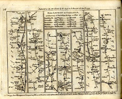
Strip map, road map, part of From London to Carlisle,
with the itinerary of the whole route, by Thomas Jefferys,
published by R Sayer and J Bennett, 53 Fleet Street, London,
1775.
Plate 38 in Jefferys's Itinerary or Travellers Companion. |
||
| map type:- | Jeffery 1775 (pl.38/Roads) | |
| map feature:- | title cartouche & plain cartouche & north point & up is destination & rivers & relief & hillocks & county & settlements & roads & road distances & distances from London | |
| inscription:- |
printed plain cartouche, upper centre
From LONDON to CARLISLE, / commencing at Darlaston Bridge, see plate 23. / Darlaston Br. 141 / Newcastle 149 / Brewerston 163 / Grulam 172 / Warrington 182 / Wigan 195 / Preston 212 / Garstang 223 / Lancaster 233 / Burton 245 / Kendal 257 / Shap 273 / Penrith 283 / Hesketh 292 / Carlisle 301 |
|
| inscription:- |
printed top
38 / Publish'd as the Acts directs by R. Sayer & I. Bennett 16 Janry. 1775. / 38 |
|
| wxh, sheet:- | 22.5x18.5cm | |
| wxh, map:- | 195x149mm | |