 Hydrographic Office 1850s onwards

|

|
|
|
item:- private collection (217) image:- © see bottom of page |
click to enlarge |
|
|
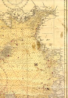
Chart, from an engraving, sheet 1979, East Coast of
Ireland with the Irish Sea and St George's and North
Channels, engraved 1886, published by the Hydrographic
Office, Taunton, Somerset, 1979.
Corrected to 1978. |
||

|
Hydrographic Office 1850s onwards | |
| map feature:- | compass rose & up is N & lat and long scales & lat and long grid & sea plain & depth soundings & depth contours & tidal streams & tide tables & sandbanks & buoys & lighthouses & coast line & foreshore sands & harbours & relief & hill hachuring & spot heights & rivers & lakes & settlements & roads & railways | |
| inscription:- |
printed upper right
EAST COAST OF / IRELAND / WITH THE IRISH SEA AND / ST GEORGE'S AND NORTH CHANNELS / COMPILED FROM THE LATEST GOVERNMENT SURVEYS 1885. / With additions and corrections to 1973. |
|
| scale:- | 1 to 487000 ? (nominal) | |