 Census 1901 map

|

|
|
|
item:- Kendal Library (35_2) image:- © see bottom of page |
click to enlarge |
|
|
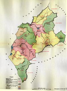
Map, colour lithograph, Cumberland, for extracts from the
Census 1901, scale about 4 miles to 1 inch, printed by the
Ordnance Survey, Southampton, Hampshire, published by HMSO,
London, 1902.
|
||

|
Census 1901 map | |
| map feature:- | folded (3x2; torn and crumpled) & table of symbols & up is N & scale line & rivers (a few) & coast line & county & registration districts (census, and sub districts) | |
| inscription:- |
printed upper centre
CUMBERLAND. |
|
| inscription:- |
printed lower right
Printed at the Ordnance Survey Office, Southampton, 1902. |
|
| inscription:- |
printed with scale line
Scale Four Miles to One Inch |
|
| scale line:- | 12+2 miles = 88.9 mm | |
| wxh, sheet:- | 53x62cm | |
| scale 1 to 250000 ? (1 to 253440 from scale line):- | ||