 Bacon c1920

|

|
|
|
item:- JandMN (378) image:- © see bottom of page |
click to enlarge |
|
|
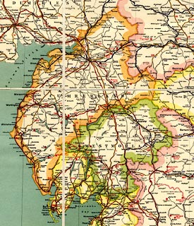
Map, colour lithograph, Map of England and Wales, scale
about 8 miles to 1 inch, by G W Bacon and Co, Norwich
Street, London, published by The Chart Publishing Co, 7 St
John Street, Oxford, about 1920.
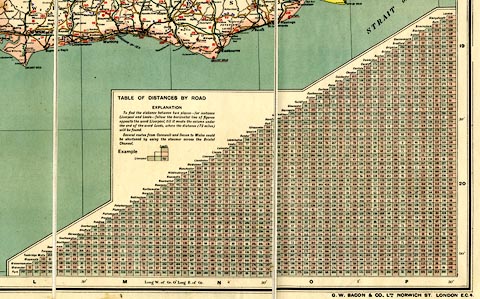
The map, in two sheets, is mounted and folded, in a slip case, there is a booklet with an index to places and itineraries of principal routes, and descriptions of some road signs. Road signs for cross roads, level crossing, steep hill, school, corner, and double corner, are just recommended for adoption by the Ministry of Transport; they were adopted 1921. A triangular table of distances is printed on the S sheet. Inset on the N sheet is a street map of London showing main roads out of town. The southern part of Scotland is included. |
||

|
Bacon c1920 | |
| map feature:- | mounted & folded (each sheet 6x3 with end boards) & slip case & table of symbols & up is N & scale line & table of distances & lat and long scales (conical projection) & lat and long grid & index grid (B-Q, 2-20, using the lat and long grid) & sea tinted & coast line & rivers & lakes & relief & spot heights & county & settlements & roads (some numbered keying to itineraries in a booklet) & road distances & railways & view points | |
| inscription:- |
printed right side of N sheet
MAP / OF / ENGLAND & WALES / SHOWING / RAILWAYS, ROADS, AND DISTANCES / ... / THE CHART PUBLISHING CO., / 7 ST. JOHN STREET, / OXFORD |
|
| inscription:- |
embossed on slip case
MAP OF / ENGLAND & WALES gold on red |
|
| inscription:- |
printed with scale line
Scale 1 inch = 8 miles. |
|
| scale line:- | 40 miles = 126.6 mm (approx) | |
| wxh, sheet:- | 101.5x73cm | |
| wxh, sheet:- | 101.5x64cm | |
| wxh, map (including gaps):- | 986x717mm | |
| wxh, map (including gaps):- | 986x605mm | |
| wxh, slip case:- | 18x25.5cm | |
| scale:- | 1 to 510000 ? (1 to 508481 from scale line) | |
|
||
|
||