 Speed 1611

|

|
|
|
item:- Armitt Library : A6632.38 image:- © see bottom of page |
click to enlarge |
|
|
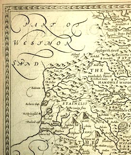
Map, uncoloured engraving, York Shire, scale about 5
miles to 1 inch, by John Speed 1610, published by Thomas
Bassett, The George, Fleet Street, and Richard Chiswell, The
Rose and Crown, St Paul's Churchyard, London, 1676.
The reverse of the map is pp. 77 and 78; text in English. Included in The Theatre of the Empire of Great Britain by John Speed. |
||

|
Speed 1611 | |
| map feature:- | picture frame border & scroll cartouche & swash lettering & coat of arms, royal & compass rose & labelled borders (English) & up is N & scale line & dividers & sea moire effect & galleons & coast shaded & rivers & relief & hillocks & parks & county & hundreds (wapontakes) & settlements | |
| inscription:- |
printed scroll cartouche, upper right
YORK SHIRE |
|
| inscription:- |
printed lower middle
Performed by Iohn Speed And are to be / sold by Thomas Bassett in Fleetstreet, and by / Richard Chiswell in St. Pauls Churchyard. |
|
| inscription:- |
printed reverse, p.77
Book 1. Chap. 39. 77 / THE Description of YORKSHIRE. / AS the courses and confluents of great Rivers, are for the most part fresh in memory, though their heads and fountains lie commonly unknown : so the later knowledge of great Regions, are not traduced to oblivion, though perhaps their first originals be obscure, by reason of Antiquity, and the many revolutions of times and ages. In the delineation therefore of this great Province of Yorkshire, I will not insist upon the narration of matters near unto us; but succinctly run over such as are more remote; yet neither so sparingly, as I may seem to diminish from the dignity of so worthy a Country, nor so prodigally, as to spend time in the superfluous praising of that which never any (as yet) dispraised. ... |
|
| inscription:- |
printed with scale line
THE SCALE OF MILES |
|
| scale line:- | 16 miles = 80.9 mm | |
| wxh, map:- | 512x383mm (about) | |
| scale:- | 1 to 320000 ? (1 to 318288 from scale line, wrongly assuming a statute mile) | |