 Garnett 1850s-60s G

|

|
|
|
item:- Armitt Library : A1187.1 image:- © see bottom of page |
click to enlarge |
|
|
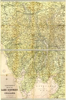
Map, two sheets, colour lithograph, Garnett's Map of the
Lake District of England, scale about 2 miles to 1 inch, by
John Bartholomew, published by John Garnett, Windermere,
Westmorland, 1870s?
Each sheet is folded and tipped in, at the front and back of A Handbook to the English Lakes, by James Payn, 12th edn. |
||

|
Garnett 1850s-60s G | |
| map feature:- | folded (4x2) & compass rose & up is N & scale line & sea plain & sandbanks & coast line & foreshore sands & rivers & lakes & relief & hill hachuring & hill shading & spot heights & woods & forests & settlements & roads & railways & canals & sands roads | |
| inscription:- |
printed lower left S sheet
GARNETT'S / MAP OF THE / LAKE DISTRICT / OF / ENGLAND. / BY J. BARTHOLOMEW. F.R.G.S. |
|
| inscription:- |
printed bottom right S sheet
[J. Bartholomew, Edinr.] trimmed off |
|
| inscription:- |
printed with scale line
SCALE 2 MILES TO AN INCH. |
|
| scale line:- | 6 miles = 76.6 mm | |
| wxh, S sheet:- | 40.5x31m | |
| wxh, N sheet:- | 40.5x31cm | |
| wxh, S map:- | 399x304mm | |
| wxh, N map:- | 399x304mm | |
| scale:- | 1 to 130000 ? (1 to 126058 from scale line) | |