 Cooper 1808

|

|
|
|
item:- Armitt Library : A214.8 image:- © see bottom of page |
click to enlarge |
|
|
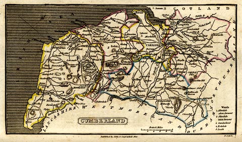
Map, hand coloured engraving, Cumberland, scale about
10.5 miles to 1 inch, drawn and engraved by Cooper, 1808,
engraved by R Scott and published by Francis Jollie and
Sons, Carlisle, Cumberland, 1811.
Tipped in opposite part 2 p.65 of Jollie's Cumberland Guide and Directory. |
||

|
Cooper 1808 | |
| map feature:- | plain cartouche & table of data & north point (skewed) & up is NW & scale line & sea shaded & coast line & rivers & lakes & relief & hill hachuring & county & settlements & roads | |
| inscription:- |
printed title cartouche and below
CUMBERLAND |
|
| inscription:- |
printed bottom centre and right
Published by Jollie & Sons Carlisle 1811 / R. Scott Sc. |
|
| inscription:- |
printed with scale line
British Miles |
|
| scale line:- | 10 miles = 24.2 mm | |
| scale:- | 1 to 660000 ? (1 to 665018 from scale line) | |
| wxh, sheet:- | 21x13cm | |
| wxh, map:- | 178x100mm | |