 Wilkes 1801-28

|

|
|
|
item:- Carlisle Library : Map 326 image:- © Carlisle Library |
click to enlarge |
|
|
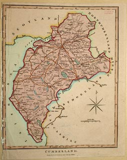
Map, hand coloured engraving, Cumberland, scale about 8
miles to 1 inch, published by John Wilkes, London, 1802.
Included in the Encyclopaedia Londinensis by John Wilkes. |
||

|
Wilkes 1801-28 | |
| map feature:- | compass rose & up is N & scale line & lat and long scales & sea plain & coast shaded & rivers & lakes & relief & hill hachuring & parks & county & settlements & roads & canals | |
| inscription:- |
printed bottom centre
CUMBERLAND. / London Pubd. as the Act directs, June 2d. 1802. by J. Wilkes. |
|
| inscription:- |
printed above scale line
British Miles |
|
| scale line:- | 10 miles = 31.3 mm | |
| longitude, Carlisle:- | 2d 51m W | |
| scale:- | 1 to 510000 ? (1 to 514167 from scale line) | |
| wxh, sheet:- | 20.5x25.5cm | |
| wxh, map:- | 189x234mm | |