 Unknown 1900s

|

|
|
|
item:- Carlisle Library : Map 321 image:- © Carlisle Library |
click to enlarge |
|
|
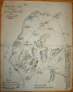
Road map, ms black and colour inks, and ink wash, Sketch
of the Roman Roads and Camps for Guarding the Western Flank
of the Roman Wall, Cumberland, Westmorland, etc, scale about
miles to 1 inch, early 20th century?
|
||

|
Unknown 1900s | |
| map feature:- | north point & up is N & scale line & sea plain & coast tinted & rivers & lakes & relief (suggested by ink wash) & roman sites & roman roads | |
| inscription:- |
ms upper left
Sketch of the Roman Roads / and Camps for guarding the Western Flank / of the / Roman Wall |
|
| inscription:- |
ms with scale line
Scale of Miles 69.14 to a Degree / Miles |
|
| scale line:- | 10 miles = 73.8 mm | |
| wxh, sheet:- | 33.5x42cm | |
| scale:- | 1 to 220000 ? (1 to 218068 from scale line, assuming ) | |
|
image:- © Carlisle Library |
|
|