 Trade Card Maps 1860s-90s

|

|
|
|
item:- Carlisle Library : Map 107 image:- © Carlisle Library |
click to enlarge |
|
|
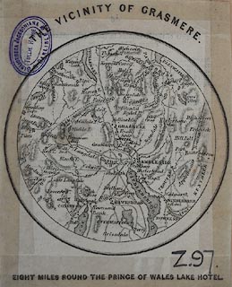
Map, uncoloured engraving, Vicinity of Grasmere, probably
from a trade card for the Prince of Wales Lake Hotel,
Grasmere, Westmorland, about 1870s.
Circular map, scale about 5.5 miles to 1 inch; the same map has been found on other trade cards. |
||

|
Trade Card Maps 1860s-90s | |
| inscription:- |
printed top
VICINITY OF GRASMERE |
|
| inscription:- |
printed bottom
EIGHT MILES ROUND THE PRINCE OF WALES LAKE HOTEL |
|
| map feature:- | up is N & scale line & rivers & lakes & relief & hill hachuring & county & settlements & roads & railways | |
| wxh, sheet:- | 8.5x10.5cm | |
| diam, map:- | 80mm | |