 Jefferys 1771

|

|
|
|
item:- private collection (196_6) image:- © see bottom of page |
click to enlarge |
|
|
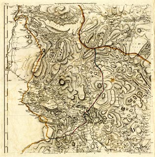
Map, hand coloured engraving, The Environs of Sedbergh,
Dent, Hawes, Askrigg, and Settle, scale about 1 inch to 1
mile, by Thomas Jefferys, 1767-1771, published by Robert
Sayer and John Bennett, 53 Fleet Street, London, 1775.
Plate 6 of A Topographical Survey of the County of York. |
||

|
Jefferys 1771 | |
| inscription:- |
printed top
The ENVIRONS of SEDBERGH, DENT, HAWES, ASKRIGG, and SETTLE. |
|
| inscription:- |
printed bottom
Corrected & Published according to act of Parliament 25 March 1775. |
|
| wxh, sheet:- | 62.5x77cm | |
| wxh, plate:- | 604x611mm | |
| wxh, map:- | 578x585mm | |
| scale:- | 1 to 64000 ? (1 to 64044 from statute scale line) | |