 Wallace 1861 map

|

|
|
|
item:- private collection (159_1) image:- © see bottom of page |
click to enlarge |
|
|
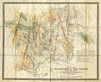
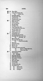
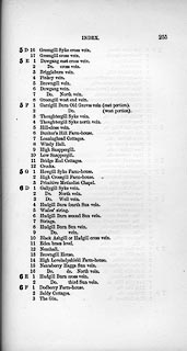
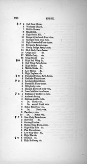
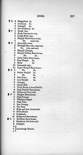
Map, colour lithograph, Map of the Alston Moor and Coal
Cleugh Mining Districts, scale about 2 inches to 1 mile, by
William Wallace, published by Edward Stanford, 6 Charing
Cross, London, 1861.
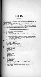
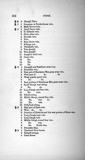
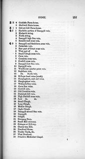
Slipped in a pocket on the back cover of The Laws which Regulate the Deposit of Lead Ore in Veins. Many features on the map are only labelled by a number within their indexed square. The numbes refer to a key, 'index', on pages 251-258 of the book in which it belongs. |
||

|
Wallace 1861 map | |
| map feature:- | folded (6x3) & table of symbols & north point & up is SE & scale line & index grid (A..L,1..10) & rivers & settlements & roads & turnpike roads & geology & mines | |
| inscription:- |
printed lower right
MAP OF THE / ALSTON-MOOR AND COAL-CLEUGH / MINING DISTRICTS; / ILLUSTRATIVE OF THE LAWS REGULATING THE FORMATION AND DIRECTION OF VEINS, / AND THOSE CONNECTED WITH THE DEPOSITION OF / LEAD ORE. |
|
| inscription:- |
printed bottom
London : Published by Edward Stanford, 6, Charing Cross, Nov. 1st. 1861. |
|
| inscription:- |
printed with scale line
SCALE OF MILES. |
|
| scale line:- | 2+1 miles = 152.6 mm | |
| wxh, sheet:- | 69x55.5cm | |
| wxh, map:- | 640x516mm | |
| scale:- | 1 to 32000 ? (1 to 31638 from scale line) | |
|
||
|
||
|
||
|
||
|
||
|
||
|
||
|
||