 Bartholomew 1880s-90s

|

|
|
|
item:- JandMN (313) image:- © see bottom of page |
click to enlarge |
|
|
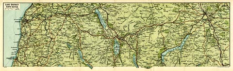
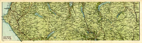
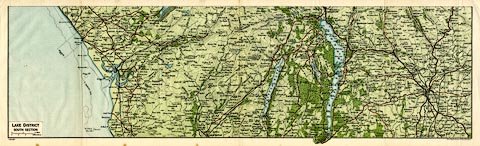
Maps, colour lithograph, 3 sheets, Lake District North
Section, ... Central Section, and ... South Section,
Westmorland and Cumberland, scale about 2 miles to 1 inch,
published by John Bartholomew and Son, Edinburgh, late 19th
century?
The maps have been folded and appear to have come from a guide book. |
||

|
Bartholomew 1880s-90s | |
| map feature:- | folded & up is N & scale line & sea tinted & coast tinted & rivers & lakes & relief & contours & spot heights & woods & forests & parks & settlements & roads & railways & canals | |
| inscription:- |
printed upper left, plain cartouche
LAKE DISTRICT / NORTH SECTION |
|
| inscription:- |
printed upper left, plain cartouche
LAKE DISTRICT / CENTRAL SECTION |
|
| inscription:- |
printed upper left, plain cartouche
LAKE DISTRICT / SOUTH SECTION |
|
| inscription:- |
printed with scale line (N section)
Miles |
|
| scale line (N section):- | 2 miles = 25.4 mm | |
| wxh, sheet:- | 54.5x17cm | |
| wxh, map (each):- | 507x145mm (approx) | |
| scale:- | 1 to 130000 ? (1 to 126720 from scale line assuming a statute mile) | |
|
||
|
||