 Senex 1719-57

|

|
|
|
item:- JandMN (309) image:- © see bottom of page |
click to enlarge |
|
|
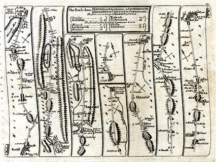
Strip map, road map, plates 82, the road from Kendal to
Cockermouth, the road from Egremond to Carlisle, in
Westmorland and Cumberland, and plate 83 the road from
King's Lynn to Harwich in Norfolk, Suffolk and Essex, scale
about 2.5 miles to 1 inch, by John Senex, 1719, published by
John Bowles and Sonthe Black Horse, Cornhill, London, 1757.
Included in The Roads through England Delineated. pl.82 - from Kendall through Ambleside, Westmorland; then Keswick to Cockermouth, Cumberland AND from Egremont, through Cockermouth to Carlisle, Cumberland. |
||

|
Senex 1719-57 | |
| map feature:- | plain cartouche & north point & up is destination & rivers & lakes & relief & hillocks & woods & parks & county & settlements & roads & road distances | |
| inscription:- |
printed title cartouche plate 82
The Roads from KENDAL in WESTMOREL : to COCKERMOUTH / EGREMOND to CARLISLE in CUMBERLAND. / The first commencing at Kendall pl.38 & so to / Stanley ... 5 / Ambleside ... 13 1/4 / Keswick 29 1/2 / Cockermouth ... 44 / The second commencing at Egremont & so to / Winnick ... 6 1/4 / Cockermouth ... 14 1/4 / Bowland ... 21 / Thursby ... 33 1/4 / CARLISLE ... 39 3/4 |
|
| inscription:- |
printed title cartouche plate83
The Road from KING'S LYNN in NORF. to HARWICH / in ESSEX / ... |
|
| wxh, sheet:- | 23x17.5cm | |
| wxh, map:- | 21x15.5cm | |