 Feltham 1803 map 2

|

|
|
|
item:- Dove Cottage : 2009.81.14 image:- © see bottom of page |
click to enlarge |
|
|
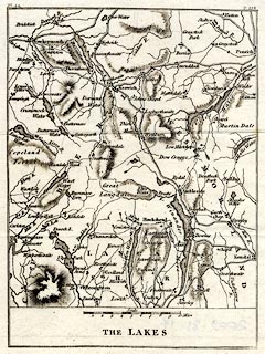
Map, The Lakes, parts of Westmorland, Cumberland, and
Lancashire, scale about 5 miles to 1 inch, by John Feltham?
published by Richard Phillips, 71 St Paul's Chuchyard,
London, 1st edn 1803
Plate 44, originally opposite p.398 in A Guide to all the Watering and Sea Bathing Places, by John Feltham. |
||

|
Feltham 1803 map 2 | |
| map feature:- | up is N & scale line & rivers & lakes & relief & hill hachuring & parks & county & settlements & roads | |
| inscription:- |
printed bottom
THE LAKES |
|
| scale line:- | 10 miles = 49.7 mm | |
| scale:- | 1 to 320000 ? (1 to 323812 from scale line) | |
| wxh, sheet:- | 16.5x20cm | |
| wxh, map:- | 129x173mm | |