 Dawson 1830s

|

|
|
|
item:- Dove Cottage : 2009.81.1 image:- © see bottom of page |
click to enlarge |
|
|
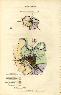
Maps, two, hand coloured lithograph, Carlisle, scales
about 1 inch to 1 mile and 4 inches to 1 mile, by Captain
Robert K Dawson, 1830s?.
Showing old borough, parliamentary borough, municipal boundary, and ward, parish and township boundaries. There are 6 pages - 3 sheets - of accompanying text from a report on Municipal Coporation Boundaries, England and Wales -- Carlisle, Report on the Proposed Municipal Boundary and Division into Wards of the City of Carisle. |
||

|
Dawson 1830s | |
| map feature:- | table of symbols & north point & up is N & scale line & rivers & settlements & roads & electoral data | |
| inscription:- |
printed top
CARLISLE. |
|
| inscription:- |
printed lower left
R. K. Dawson Lt RE |
|
| inscription:- |
printed with upper scale line
Scale 1 Inche to a Mile |
|
| scale line:- | 1+1 miles = 49.7 mm | |
| inscription:- |
printed with scale line
Scale 4 Inches to a Mile |
|
| scale line:- | 1 mile = 98.8 mm | |
| wxh, sheet:- | 21x33cm | |
| scale:- | 1 to 65000 ? (1 to 64762 from scale line, assuming a statute mile) | |
| scale:- | 1 to 16000 ? (1 to 16289 from scale line, assuming a statute mile) | |