 Robertson 1911 maps

|

|
|
|
item:- JandMN (197_39) image:- © see bottom of page |
click to enlarge |
|
|
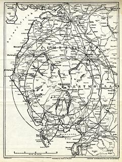
Map, lithograph, showing Wordsworthshire, scale about 7
miles to 1 inch, by G W Bacon and Co, for Eric Robertson,
published by Chatto and Windus, London, 1911.
Folded and tipped in opposite p.221 of Wordsworthshire by Eric Robertson. Centred on Grasmere, with distance circles, the inner circle being the 'Heart of Wordsworthshire'. |
||

|
Robertson 1911 maps | |
| map feature:- | up is N & scale line & sea plain & coast line & rivers & lakes & relief & spot heights & county & settlements & roads & railways | |
| inscription:- |
printed bottom left, centre, right
COPYRIGHT / Published by Chatto & Windus / LONDON : G W BACON & C0., LTD. 127 STRAND. |
|
| inscription:- |
printed with scale line
SCALE OF MILES |
|
| scale line:- | 20 miles = 70.6 mm | |
| wxh, sheet:- | 22x28.5cm | |
| wxh, map:- | 189x253mm | |
| scale:- | 1 to 460000 ? (1 to 455905 from scale line) | |