 Garnett 1871

|

|
|
|
item:- JandMN (192_2) image:- © see bottom of page |
click to enlarge |
|
|
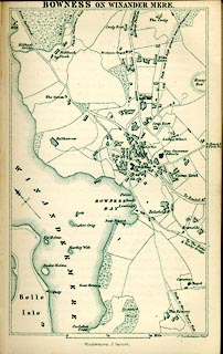
Map, lithograph town plan, Bowness on Winander Mere,
scale about 6 inches to 1 mile, engraved by J Bartholomew,
published by John Garnett, Windermere, Westmorland, 1871.
Tipped in opposite p.22 of A Complete Guide to the Lake District of England, by Harriet Martineau, 4th edn 1871. While it is probably based on the OS 6 inch map, the labelling appears to reflect the local interest of Mr Garnett. The map is printed in monochrome pale green, as are many of John Garnett's maps. |
||

|
Garnett 1871 | |
| map feature:- | north point & up is NE & scale line & rivers & lakes & relief & hill hachuring & woods & settlements & roads & railways (mentioned) | |
| inscription:- |
printed top
BOWNESS IN WINANDER MERE |
|
| inscription:- |
printed bottom right, centre
J. Bartholomew, Edinr. / Windermere : J. Garnett. |
|
| scale line:- | 0.25 mile = 38.1 mm | |
| wxh, sheet:- | 10x16cm | |
| wxh, map:- | 91x149mm | |
| scale:- | 1 to 10560 ? (1 to 10560 from scale line) | |