 Bowen and Bowen 1767

|

|
|
|
item:- Armitt Library : ALMC2008.14.120 image:- © see bottom of page |
click to enlarge |
|
|
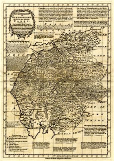
Map, uncoloured engraving, Cumberland and Westmorland,
scale about 9 miles to 1 inch, by Emanuel Bowen and Thomas
Bowen, London, published by Thomas Kitchin, 59 Holborn Hill,
London, about 1767.
From the Atlas Anglicanus, Or a Complete Sett of Mapps of the Counties of South Britain. |
||

|
Bowen and Bowen 1767 | |
| map feature:- | baroque cartouche & table of symbols & descriptive text & compass rose & up is N & scale line & lat and long scales (rectangular projection, W from London) & lat and long grid & sea plain & coast form lines & rivers & lakes & relief & hillocks & forests & parks & county & settlements & roads & road distances & market days | |
| inscription:- |
printed title cartouche, upper left
CUMBERLAND / and / WESTMORLAND, / Divided into their respective / WARDS. / Exhibiting the / City, Borough & Market Towns &c. / with Historical Extracts relative to their / Natural Produce, Trade & Manufactures. / Describing also the Church Livings, with / Improvements not Inserted in any other / Set of Half Sheet County Maps Extant. / By Eman : Bowen Geogr. / & Thos. Bowen. |
|
| inscription:- |
printed bottom
Printed for Tho. Kitchin at No.59 Holborn Hill London. |
|
| inscription:- |
printed above scale line
British Statute Miles |
|
| scale line:- | 16 miles = 44.9 mm | |
| longitude, Kendal:- | 2d 50.8m W (approx) | |
| scale:- | 1 to 570000 ? (1 to 573486 from scale line assuming a statute mile) | |
| wxh, sheet:- | 26x39cm | |
| wxh, plate:- | 234x330mm | |
| wxh, map:- | 226x321mm | |