 Hondius 1607

|

|
|
|
item:- Armitt Library : ALMC2008.14.15 image:- © see bottom of page |
click to enlarge |
|
|
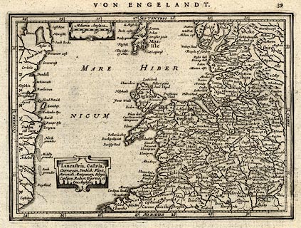
Map, uncoloured engraving, Lancastria, Cestria ... ie
Lancashire, Cheshire ..., part of England, scale about 28
miles to 1 inch, probably engraved by Peter Keer, published
by John Jansson, Amsterdam, Netherlands, 1630s.
The text on the reverse, page 40, is in German in a gothic typeface, the map is on page 39, which identifies the map as coming from an edition of Atlas Minor Gerardi Mercatoris, 1628 onwards. The map is a new engraving, probably by Pieter van den Keere, from the small map by Jodocus Hondius 1607, derived from Mercator's larger map 1595, for a new edition of Gerard Mercator's Atlas Minor. |
||

|
Hondius 1607 | |
| map feature:- | scroll cartouche (sort of) & scale line & labelled borders (Latin) & up is N & lat and long scales (rectangular projection? longitude E from some in the Atlantic) & sea plain & coast shaded & rivers & lakes & relief & hillocks & county & settlements | |
| inscription:- |
printed title cartouche, lower left
Lancastrai, Cestria, / Caernarvan, Denbich, Flint, / Meriodih, Montgomery, Salopia, / Cardigan, Radnor, Wigornia, et / Ins. Anglesey |
|
| inscription:- |
printed top right
ia page/plate number |
|
| inscription:- |
printed top
VON ENGELANDT. |
|
| inscription:- |
printed above scale line, upper left
Miliaria Anglica |
|
| scale line:- | 30 miles = 27.2 mm | |
| wxh, sheet:- | 23.5x19cm | |
| wxh, plate:- | 206x149mm | |
| wxh, map:- | 202x146mm | |
| scale:- | 1 to 1800000 ? (1 to 1775012 from scale line wrongly assuming a statute mile) | |