 Wallis 1812

|

|
|
|
item:- Dove Cottage : 2009.81.18 image:- © see bottom of page |
click to enlarge |
|
|
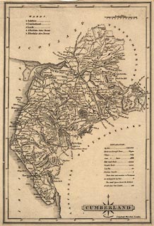
Map, uncoloured engraving, Cumberland, scale about 8
miles to 1 inch, by James Wallis, London, 1812.
Published in A New and Improved County Atlas, 1812. |
||

|
Wallis 1812 | |
| map feature:- | compass rose cartouche & compass rose & up is N & scale line & lat and long scales & sea plain & coast shaded & rivers & lakes & relief & hill hachuring & parks & county & wards (hundreds) & table of wards (hundreds) & settlements & roads & canals | |
| inscription:- |
printed title cartouche, lower right
CUMBERLAND / Engrav'd by J. Wallis. |
|
| scale line:- | 12 miles = 37.9 mm | |
| scale:- | 1 to 510000 ? (1 to 509555 from scale line) | |
| wxh, sheet:- | 19x27cm | |
| wxh, map:- | 176x262mm | |