 Greenwood 1834

|

|
|
|
item:- private collection (12) image:- © see bottom of page |
click to enlarge |
|
|
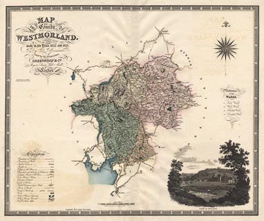
Map, hand coloured engraving, Map of the County of
Westmorland, scale about 3 miles to 1 inch, by C and J
Greenwood, 1822-23, engraved by J and C Walker, 1830,
published by Greenwood and Co, 13 Regent Street, Pall Mall,
London, 1830-34.
|
||

|
Greenwood 1834 | |
| map feature:- | compass rose & up is N & scale line & lat and long scales & table of symbols & coast line & coast form lines & rivers & lakes & relief & hill hachuring & woods & forests & parks & vignettes (View of Appleby) & county & wards & table of wards & settlements & roads & canals & electoral data | |
| inscription:- |
printed upper left
MAP / OF / THE COUNTY OF / WESTMORLAND. / from an Actual Survey / made in the Years 1822 and 1823 / By C. & J. Greenwood / Pubd. by the Proprietors / GREENWOOD & Co. / 13, Regent Street, Pall Mall, / London / Corrected to the present Period & Published Feby. 24th. 1830. |
|
| inscription:- |
printed left above centre
ENGRAVED BY J. & C. WALKER / 47 BERNARD ST. RUSSEL SQUARE |
|
| scale line:- | 10+1 miles = 90.2 mm | |
| scale:- | 1 to 200000 ? (1 to 196261 from scale line assuming a statute mile) | |
| wxh, map:- | 700x581mm | |