 Stanford 1864

|

|
|
|
item:- JandMN (141) image:- © see bottom of page |
click to enlarge |
|
|
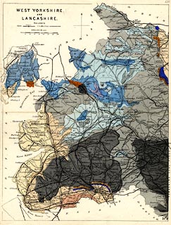
Geological map, colour printed, West Yorkshire and
Lancashire, scale about 10.5 miles to 1 inch, published by
Edward Stanford, London, after 1864.
Perhaps included in Stanford's Geological Atlas of Great Britain and Ireland. The map border differs from some other maps, or editions, in the series, and it has no OS map sheet index. The areas of solid geology are coloured and labelled with a number that refers to a table of strata near the front of the atlas - the right edition of the atlas must be used as colouring varies from edition to edition. |
||

|
Stanford 1864 | |
| inscription:- |
printed
WEST YORKSHIRE / AND / LANCASHIRE |
|
| scale line:- | 16 miles = 38.9 mm | |
| scale:- | 1 to 660000 ? (1 to 661941 from scale line) | |