 Bell 1833

|

|
|
|
item:- Dove Cottage : 2007.38.108 image:- © see bottom of page |
click to enlarge |
|
|
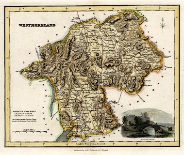
Map, hand coloured steel engraving, Westmoreland ie
Westmorland, scale about 5.5 miles to 1 inch, by James Bell?
published by Archibald Fullarton and Co, Glasgow,
Strathclyde, about 1834.
Lower right is a vignette scene of Brough Castle. Probably from A Parliamentary Gazetteer of England and Wales, by James Bell, 1843. |
||

|
Bell 1833 | |
| map feature:- | vignettes (Brough Castle) & compass rose & up is N & scale line & lat and long scales & sea shaded & coast line & rivers & relief & hill hachuring & parks & county & wards (hundreds) & settlements & roads & canals | |
| inscription:- |
printed upper left
WESTMORELAND |
|
| inscription:- |
printed bottom centre
Pubished by Archd. Fullarton & Co. |
|
| inscription:- |
printed with scale line
English Miles. |
|
| scale line:- | 10 miles = 47.3 mm | |
| longitude, Kendal:- | 2d 43.9m W (?) | |
| scale:- | 1 to 340000 ? (1 to 340242 from scale line) | |
| wxh, sheet:- | 30.5x25cm | |
| wxh, map:- | 243x195mm | |