 Kitchin 1763

|

|
|
|
item:- Dove Cottage : 2007.38.107 image:- © see bottom of page |
click to enlarge |
|
|
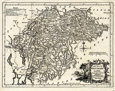
Map, uncoloured engraving, A New Map of Westmoreland ie
Westmorland, scale about 6 miles to 1 inch, by Thomas
Kitchin, 1763, published by R and J Dodsley, Pall Mall,
London, 1763-64.
Included in England Illustrated. |
||

|
Kitchin 1763 | |
| map feature:- | baroque cartouche & table of symbols & compass rose & up is N & scale line & lat and long scales (West from London) & lat and long grid (just) & sea plain & coast shaded & rivers & lakes & relief & hill hachuring & woods & forests & parks & county & settlements & roads | |
| inscription:- |
printed title cartouche, lower right
A New Map of / WESTMORE- / -LAND, / Drawn from the best / Authorities : / By Thos. Kitchin Geogr. / Engraver to H.R.H. the / Duke of York. |
|
| inscription:- |
printed above scale line
British Statute Miles 69 to a Degree. |
|
| scale line:- | 10 miles = 42.1 mm | |
| longitude, Kendal:- | 2d 50.9m W | |
| scale:- | 1 to 380000 ? (1 to 382267 from scale line) | |
| wxh, sheet:- | 29x23cm | |
| wxh, plate:- | 262x201mm | |
| wxh, map:- | 256x194mm | |