 Walker 1837

|

|
|
|
item:- Dove Cottage : 2007.38.93 image:- © see bottom of page |
click to enlarge |
|
|
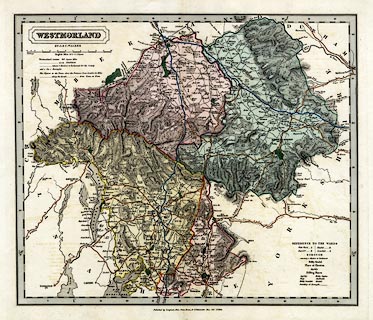
Map, hand coloured engraving, Westmorland, scale about 3
miles to 1 inch, by J and C Walker, published by Longman,
Rees, Orme, Brown, Etc, Paternoster Row, London, about 1836.
From the British Atlas, 1837. |
||

|
Walker 1837 | |
| map feature:- | plain cartouche & up is N & scale line & lat and long scales (trapezoidal projection) & coast shaded & rivers & relief & hill hachuring & woods & forests & parks & county & electoral data & wards (hundreds) & settlements & roads & canals | |
| inscription:- |
printed plain cartouche, upper left
WESTMORLAND / BY J. & C. WALKER |
|
| inscription:- |
printed bottom
Published by Longman, Rees, Orme, Brown, & Co. Paternoster Row, Octr. 1st. 1836. |
|
| scale line:- | 10+1 miles = 92.4 mm | |
| scale:- | 1 to 190000 ? (1 to 191589 from scale line) | |
| wxh, sheet:- | 46.5x37cm | |
| wxh, map:- | 377x319mm | |