 Blaeu 1645

|

|
|
|
item:- Dove Cottage : 2007.38.24 image:- © see bottom of page |
click to enlarge |
|
|
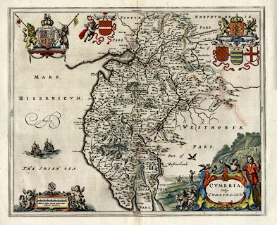
Map, hand coloured engraving, Cumbria vulgo Cumberland,
scale about 3.5 miles to 1 inch, by Johann Blaeu, Amsterdam,
Netherlands, 1645.
From Theatrum Orbis Terrarum sive Atlas Novus, part 4. There is text pp.415-416, in Latin, for Cumberland, on the reverse. The same map is used in a series of editions in Latin to about 1662. As well as the royal arms of the Stuart period, there are coats of arms of Henry Clfford Earle, Marcatus E., Ran Meschems, Andrew Harkley, and of England. |
||

|
Blaeu 1645 | |
| map feature:- | scroll cartouche (and a pastoral scene) & coat of arms & swash lettering (a little) & labelled borders (Latin) & up is N & scale line & sea plain & galleons & coast shaded & rivers & bridges & lakes & relief & hillocks & woods & forests & parks & county & settlements | |
| inscription:- |
printed title cartouche, lower right
CUMBRIA, / Vulgo / CUMBERLAND.. |
|
| inscription:- |
printed below the scale line, lwoer left
Milliaria Anglica quorum quatuor unum / Constituunt Germanicum. |
|
| scale line:- | 8 miles = 56.9 mm | |
| scale:- | 1 to 230000 ? (1 to 226270 from scale line wrongly assuming a statute mile) | |
| wxh, sheet:- | 59.5x50.5cm | |
| wxh, plate:- | 506x417mm | |
| wxh, map:- | 502x412mm | |
|
|
notes | |