 Black 1884 map

|

|
|
|
item:- JandMN (59_2) image:- © see bottom of page |
click to enlarge |
|
|
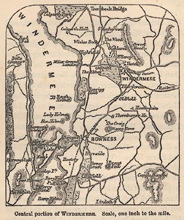
Map, engraving, Central Portion of Windermere,
Westmorland, scale about 1 inch to 1 mile, about 1884.
Printed on page 1 of Black's Guide to The Lakes, published by Adam and Charles Black, Edinburgh, Lothian, 16th edn 1884 |
||

|
Black 1884 map | |
| inscription:- |
printed bottom
Central portion of WINDERMERE. Scale, one inch to one mile. |
|
| scale:- | 1 to 63360 ? (nominal) | |
| wxh, map:- | 70x82mm | |