 Moll 1724

|

|
|
|
item:- private collection (29) image:- © see bottom of page |
click to enlarge |
|
|
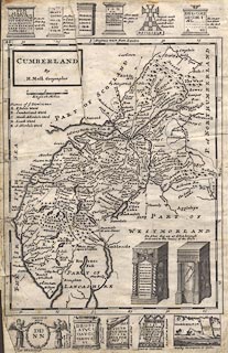
Map, uncoloured engraving, Cumberland, scale about 7
miles to 1 inch, by Hermann Moll, published London, 1724.
In spare spaces and at top and bottom of the map there are vignettes of antiquities, mostly roman altars. Plate 48 from A New Description Of England and Wales, With the Adjacent Islands, or a later edition. |
||

|
Moll 1724 | |
| map feature:- | plain cartouche & up is N & scale line & lat and long scales & sea plain & coast shaded & rivers & lakes & relief & hillocks & woods & forests & parks & county & wards (hundreds) & table of wards & settlements & roads & road distances & vignettes | |
| inscription:- |
printed title cartouche, upper left
CUMBERLAND / By / H. Moll Geographer |
|
| inscription:- |
printed with scale line
English Miles |
|
| scale line:- | 10 miles = 37.6 mm | |
| scale:- | 1 to 430000 ? (1 to 428108 from scale line) | |
| wxh, sheet (badly trimmed):- | 22x33cm | |
| wxh, map:- | 203x256mm | |