 Smith 1746 map 1

|

|
|
|
item:- Hampshire Museums : B1999.518.1746.map image:- © see bottom of page |
click to enlarge |
|
|
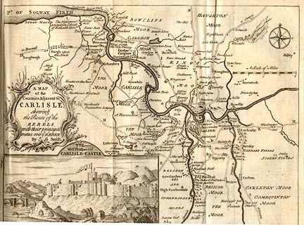
Map, uncoloured engraving, Map of the Countries Adjacent
to Carlisle shewing the Route of the Rebels, scale about 1
inch to 1 mile, by G Smith, published in the Gentleman's
Magazine, London, 1746.
Vol.16 1746, with article pp.233-236. The rebels are the Scots of the 1745 rebellion; lower left is a vignette view, the West Prospect of Carlisle Castle. |
||

|
Smith 1746 map 1 | |
| map feature:- | baroque cartouche & compass rose & up is N & scale line & coast form lines & rivers & relief & hillocks & settlements & roads & vignettes | |
| inscription:- |
printed title cartouche
A MAP / of the / Countries Adjacent to / CARLISLE / shewing / the Route of the / REBELS / with their principal / Ford over ye Rr. EDEN. / By G. Smith. |
|
| scale line:- | 2 miles = 56.4 mm | |
| wxh:- | 26.5x20.5cm | |
| scale:- | 1 to 57000 ? (1 to 57069 from scale line assuming statute mile) | |