 Cary 1787

|

|
|
|
item:- Dove Cottage : Lowther.39 image:- © see bottom of page |
click to enlarge |
|
|
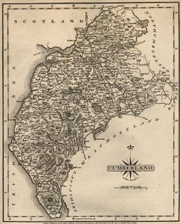
Map, uncoloured engraving, Cumberland, scale about 6.5
miles to 1 inch, by John Cary, 188 Strand, London, 1787.
Included in Cary's New and Correct English Atlas, 1787 etc. Tipped into the Lowther scrapbook, vol.3; between pp.4-5; with its descriptive text:- CUMBERLAND IS a maritime county, which gives the title of Duke to a branch of the Royal Family; and, during the Saxon heptarchy, belonged to the kingdom of the Northumbrians, though by some supposed to have belonged to the kingdom of Scotland, on the borders of which it is situated. It is now in the province of York, in the dioceses of Chester and Carlisle, and in the Northern Circuit. It is 53 miles long, and 45 miles broad, and 225 miles in circuit; containing 1530 square miles, or 979,200 square acres, divided into 5 wards, having 58 parishes, 7 vicarages, 447 villages, one city, Carlisle, which gives the title of Earl to the family of Howard, is a bishop's see, and sends 2 members to Parliament; and 14 market towns, viz. Cockermouth, which gives the title of Baron to the Wyndham family, and sends 2 members to Parliament; Egremont, which gives the title of Earl to the same noble family; Penrith, Whitehaven, Keswick, Ravenglass, Alncester, Holm, Brampton, Alston Moor, Ireby, Kirk Oswald, Longtown, and Wigton; among the villages, Delaval gives the title of Baron to a family of that name; Greystock, the same honour to the family of Howard; Gillesland, the title of Baron to the same noble family. Its principal rivers are the Eden, Aln, Irt, Petterel, Caude, Darwent, Cocker, Duddon, Leven, Esk, Wiza, and Tyne. Remarkable places in this county are Moricambo Bay, Derwent Foot Haven, and Solway Frith; with Cheviot Hills, Hard Knot Hills, Mole Hill, Dentshill, Skiddaw Mount, and Wrynose; The Fells, Penrith Fells, Newton Beacon; Derwent, Ulles, and Broad-water Lakes; as well as those of Bassingthwaite, Lowater, Wasdale and Dalgarth Lakes, with a few other smaller ones; Geltsdale, Westward, Copeland, and Englewood Forests. This county is very mountainous, and has more roman antiquities than any other in the kingdom; of which the Picts' Wall, which passes through this county, is no inconsiderable part, built by Adrian in 121, which crossed the whole island from sea to sea about 100 miles, was 8 feet broad, and 12 high; besides which there were 25 strong castles, and all the houses of the nobility and gentry were built castle-wise, to defend them from the incursions of the Scots and Picts; here also ended the great Roman highway. This county produces black lead, copper , iron, coals, lapis calaminaris, game, fish, &c. and has manufactories of fustians, coarse woollens, linen, &c. It sends 6 members to Parliament, viz. 2 for the county, and 4 others as above mentioned; pays one part of the land-tax, and provides 200 men to the national militia. There is a medical spring in Lanercost. The most remarkable seats are, Allerby Hall, near Cockermouth. Brayton Hall, near Wigton. Camerton Hall, near Workington. Clea Hall, near Wilton. Corby Castle, near Carlisle. Crookrake Hall, near Wigton. Gowbarrow Park, near Penrith. Greystock, near Penrith. Hail Hall, near Egremont. How Hall, near Ennerdale. Hutton Park, near Penrith. Irton, near Ravenglass. Isle, near Cockermouth. Moncastle Hall, near Ravenglass. Naward Castle, near Brampton. Ulpha Park. Whitehall, near Heskett. The most remarkable Views are those from, Keswick Lake, or Derwent-water, at the Foot of Skiddow. Ulleswater. Irton Hall. The West Side of Dunmallert-hill. Borodale, and the Top of Craig Castle. Lawdown Waterfall and Grange. Braithwaite Brewes. Beacon-Hill, near Penrith. Warnal, near Rose Castle. Mole, at Brampton. Bassingthwaite Water. From Ewsbridge. Blackomb, near Millum, has an extended view of 100 miles. |
||

|
Cary 1787 | |
| map feature:- | compass rose cartouche & compass rose & up is N & scale line & lat and long scales & sea plain & coast form lines & rivers & lakes & relief & hill hachuring & forests & parks & county & settlements & roads | |
| inscription:- |
printed bottom
London : Published as the Act directs, September 1st. 1787, by J. Cary, Engraver, Map & Print seller, No.188, the corner of Arundel Street Strand. |
|
| scale line:- | 10 miles = 38.1 mm | |
| wxh, sheet:- | 24x27.5cm | |
| wxh, map:- | 212x264mm | |
| scale:- | 1 to 420000 ? (1 to 422400 from the scale line assuming a statute mile) | |
|
from:- Scrapbook, 4 volumes, History of Westmorland and Cumberland Illustrated, of descriptive texts, maps, and prints of views and coats of arms, for Westmorland and Cumberland, assembled by a member of the Lowther Family, late 18th early 19th century. The volumes are quarter bound, with marbled paper on the covers; each has a bookplate inside the front cover. The pages cut from various sources are nicely mounted, two sided pieces set neatly in a window in the scrapbook page. The main content is the whole of the two volumes of The History and Antiquities of the Counties of Westmorland and Cumberland, by Joseph Nicolson and Richard Burn, published London, 1777. Nicolson and Burn volume 1 is in scrapbook volumes 1 and 2, volume 2 in scrapbook volumes 3 and 4. Maps and prints are interspersed to make an illustrated version of the history. Some of the sources of maps and prints have been recognised:- Maps - coast of Cumberland etc by Andrew Dury, 1764; Westmorland and Cumberland by Richard Blome, 1673; sheets from Britannia Depicta, Emanuel Bowen, 1720; Cumberland by John Speed, Henry Overton edn 1695; Cumberland by John Cary 1787. Prints from the Set of prints, 20 engravings, Views of the Lakes etc in Cumberland and Westmorland, drawn by Joseph Farington, published by William Byrne, London, 1789. Note that plate numbers vary from edition to edition of this set. Prints from the Antiquities of Great Britain, drawings by Thomas Hearne, engraved by William Byrne, published by Hearne and Byrne, London, 1786-1807. Prints from Britannia Illustrata, drawings by Leonard Knyff, engraved by John Kip, published London, 1707-1740. Print from A Tour in England and Scotland, by Thomas Newte, published by G G J and J Robinson, Paternoster Row, London, 1788.. Some of the coat of arms are cut from A Display of Heraldrie by John Guillim late Pursuivant at Armes, published London, about 1610-11 to 1755. Coats of arms probably from The Baronetage of England, by Edward Kimber and Richard Johnson, published London? 1771. Pages from The Antiquarian Repertory, by Francis Grose, Thomas Astle, et al, published London, 1775-1809. Text from the Baronetage of England by Collins? Scraps cut from an unidentified gazetteer. At the end is the title page and pp.7-51 from A General View of the Agriculture of the County of Cumberland, by John Bailey and George Culley, published by C Macrae, London, 1794. Individual maps and prints are documented separately; with a note of their position in the scrapbooks. inscription:- : embossed: label on spine: (tatty remains): HI[ ] / [ ]/WEST[ ]M[ ] / [ ] / CUM[ ]M[ ] / ILLUS[ ]T[E ] inscription:- : printed & embossed: bookplate: gold on grey; crest, 6 annulets from the coat of arms, flowers, thistles: LOWTHER |
||