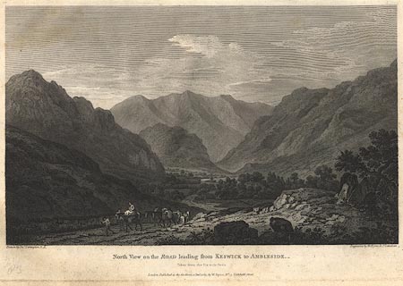
 North View on the Road Leading from Keswick to
Ambleside
North View on the Road Leading from Keswick to
Ambleside

|

|
|
|
item:- Dove Cottage : Lowther.49 image:- © see bottom of page |
click to enlarge |
|
|
Print, engraving, North View on the Road Leading from
Keswick to Ambleside, painted by Joseph Farington, engraved
by W Byrne and J Landseer, published by W Byrne, 79
Titchfield Street, London, 1789.
The six milestone from Keswick is just south of the King's Head, Thirlspot, on the left is Castlerigg Fell, and the view looks down St John's in the Vale. Plate 18 from Views of the Lakes, &c, in Cumberland and Westmorland, published 1789. Pasted in the Lowther scrapbook, vol.3; between pp.78-79; with descriptive text:- VIEW on the ROAD leading from AMBLESIDE to KESWICK. / THE Road from Ambleside to Keswick affords a Series of romantic and picturesque Views, which cannot fail of impressing the Imagination of the Traveller in an extraordinary Manner. Indeed, it is scarcely possible to find a Succession of Scenes more various and contrasted. After passing the charming Scenery of Rydal, and the wild Environs which surround the Lake of that Name, from the Top of a steep Ascent, the peaceful embossomed Grassmere presents itself. Pursuing the way from this sequestered and beautiful Retreat, by a long ascending Road, a Height is gained which commands the Vale left behind, so as to produce what is termed a Bird's-Eye View. Grassmere becomes a small Feature in this extensive Landscape, and the inclosures of the cultivated Vale are crowded together like the Divisions in a Map. Though it does not come within the Power of the Pencil to give an ample Idea of such Scenes, yet upon the great Scale of Nature they are always affecting.- Descending on the North Side, Wythburn or Leathes Water, comes into the View, which is of a wild and barren Character. The Road passes a considerable Way on the Margin of that Lake, when it becomes again steep and winding; but the Tediousness of Alpine travelling is compensated by the Scene which opens from the Six Mile Stone, on this Side Keswick.- It is this View which is attempted to be described in the annexed Plate.- Between lofty Mountains on the right, and Rocks of high and rude Forms on the left, passes the narrow green Vale of Legberthwaite, which is divided into small Inclosures, and peopled with a few Cots. The Vale is terminated by the romantick Rock of St. John; behind which rises Saddleback, a Mountain almost vying with Skiddaw for pre-eminence, and forming a sublime Back Ground to the Scene. / XVIII. |
||
| source type:- | Farington 1789 (plate 18) | |
| inscription:- |
printed bottom, left, right, centre
Drawn by Josh. Farington R.A./ Engraved by W. Byrne & J. Landseer. / North View on the ROAD leading from KESWICK to AMBLESIDE. / Taken from the Six mile stone. / London : Published as the Act directs, 1 Jany. 1789, by W. Byrne, No.79 Titchfield Street. |
|
| wxh:- | 34.5x24cm | |
|
from:- Scrapbook, 4 volumes, History of Westmorland and Cumberland Illustrated, of descriptive texts, maps, and prints of views and coats of arms, for Westmorland and Cumberland, assembled by a member of the Lowther Family, late 18th early 19th century. The volumes are quarter bound, with marbled paper on the covers; each has a bookplate inside the front cover. The pages cut from various sources are nicely mounted, two sided pieces set neatly in a window in the scrapbook page. The main content is the whole of the two volumes of The History and Antiquities of the Counties of Westmorland and Cumberland, by Joseph Nicolson and Richard Burn, published London, 1777. Nicolson and Burn volume 1 is in scrapbook volumes 1 and 2, volume 2 in scrapbook volumes 3 and 4. Maps and prints are interspersed to make an illustrated version of the history. Some of the sources of maps and prints have been recognised:- Maps - coast of Cumberland etc by Andrew Dury, 1764; Westmorland and Cumberland by Richard Blome, 1673; sheets from Britannia Depicta, Emanuel Bowen, 1720; Cumberland by John Speed, Henry Overton edn 1695; Cumberland by John Cary 1787. Prints from the Set of prints, 20 engravings, Views of the Lakes etc in Cumberland and Westmorland, drawn by Joseph Farington, published by William Byrne, London, 1789. Note that plate numbers vary from edition to edition of this set. Prints from the Antiquities of Great Britain, drawings by Thomas Hearne, engraved by William Byrne, published by Hearne and Byrne, London, 1786-1807. Prints from Britannia Illustrata, drawings by Leonard Knyff, engraved by John Kip, published London, 1707-1740. Print from A Tour in England and Scotland, by Thomas Newte, published by G G J and J Robinson, Paternoster Row, London, 1788.. Some of the coat of arms are cut from A Display of Heraldrie by John Guillim late Pursuivant at Armes, published London, about 1610-11 to 1755. Coats of arms probably from The Baronetage of England, by Edward Kimber and Richard Johnson, published London? 1771. Pages from The Antiquarian Repertory, by Francis Grose, Thomas Astle, et al, published London, 1775-1809. Text from the Baronetage of England by Collins? Scraps cut from an unidentified gazetteer. At the end is the title page and pp.7-51 from A General View of the Agriculture of the County of Cumberland, by John Bailey and George Culley, published by C Macrae, London, 1794. Individual maps and prints are documented separately; with a note of their position in the scrapbooks. inscription:- : embossed: label on spine: (tatty remains): HI[ ] / [ ]/WEST[ ]M[ ] / [ ] / CUM[ ]M[ ] / ILLUS[ ]T[E ] inscription:- : printed & embossed: bookplate: gold on grey; crest, 6 annulets from the coat of arms, flowers, thistles: LOWTHER |
||