 W H Smith c1889

|

|
|
|
item:- private collection (39) image:- © see bottom of page |
click to enlarge |
|
|
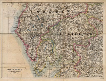
Map, colour lithograph? Environs of Windermere and the
Lake District, scale about 4 miles to 1 inch, by John
Bartholomew, Edinburgh, published by W H Smith and Son,
London, about 1889.
|
||

|
W H Smith c1889 | |
| map feature:- | mounted & folded & card cover & scale line & lat and long grid (no scales) & sea plain & coast tinted & rivers & lakes & relief & hill hachuring & parks & county & settlements & roads & railways & canals | |
| inscription:- |
printed lower left
ENVIRONS OF / WINDERMERE / & THE LAKE DISTRICT. |
|
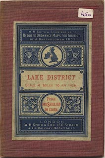
| inscription:- |
printed label on cover
W. H. SMITH & SON'S SERIES OF / REDUCED ORDNANCE MAPS FOR TOURISTS. / BY J. BARTHOLOMEW. F.R.G.S. / LAKE DISTRICT / SCALE 4 MILES TO AN INCH. / PRICE / ONE SHILLING / ON CLOTH. / LONDON / W. H. SMITH & SON, 186, STRAND / & ALL RAILWAY BOOK STALLS red and blue on white, lettering reversed out; foliage decoration and outline British Isles |
|
| inscription:- |
ms inside cover
April 23rd. 1889 ... |
|
| scale line:- | 8 miles = 49.8 mm | |
| scale:- | 1 to 260000 ? (1 to 258529 from scale line) | |
| wxh, cover:- | 10.5x16cm | |
| wxh, folded:- | 9.5x15.5cm | |
| wxh, sheet:- | 48.5x36.5cm | |
| wxh, map:- | 466x345mm | |
|
||
|
||
|
||