 Cole and Roper 1805

|

|
|
|
item:- JandMN (4) image:- © see bottom of page |
click to enlarge |
|
|
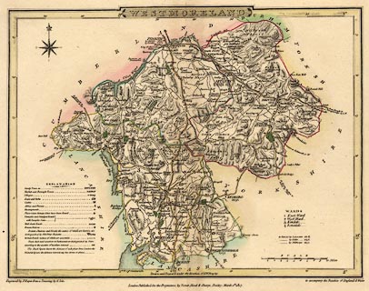
Map, hand coloured engraving, Westmoreland ie
Westmorland, scale about 6 miles to 1 inch, by G Cole,
engraved by J Roper, published by Vernor, Hood and Sharpe,
Poultry, London, 1835?
To accompany the Beauties of England and Wales by E W Brayely and J Britton; plate 40. |
||

|
Cole and Roper 1805 | |
| map feature:- | plain cartouche & table of symbols & compass rose & up is N & scale line & lat and long scales (W of Greenwich) & coast form lines & rivers & lakes & relief & hill hachuring & forests & parks & county & wards & table of wards & settlements & roads & turnpike roads & post roads & road distances & distances from London | |
| inscription:- |
printed title cartouche, top centre
WESTMORELAND |
|
| inscription:- |
printed lower centre
Drawn and Engraved under the direction of E. W. Brayley. |
|
| inscription:- |
printed bottom, left, centre, right
Engraved by J. Roper from a drawing by G. Cole. / London : Published by Vernor, Hood & Sharpe, Poultry. March 1st. 1807. / to accompany the Beauties of England & Wales. |
|
| inscription:- |
watermark:
J WHATMAN / 1805 |
|
| inscription:- |
printed with scale line
SCALE / Miles |
|
| scale line:- | 10 miles = 42.5 mm | |
| scale:- | 1 to 380000 ? (1 to 378669 from scale line) | |
| wxh, sheet:- | 27x21.5cm | |
| wxh, map:- | 231x177mm | |
|
|
notes | |