 OS 1904

|

|
|
|
item:- JandMN (25) image:- © see bottom of page |
click to enlarge |
|
|
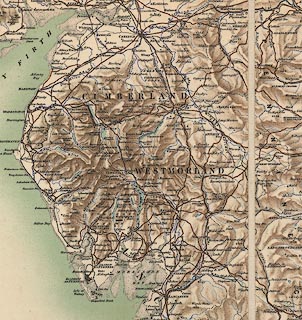
Map, England and Wales, relief, roads and railways, scale
about 10 miles to 1 inch, by Ordnance Survey, Southampton,
Hampshire, 1904.
The map is sectioned for folding, mounted, in a slip case; it has been assembled from separate sheets, presumably by the retailer, Edward Stanford, Long Acre, London, about 1904. |
||

|
OS 1904 | |
| map feature:- | sectioned for folding & mounted & slip case & up is N & scale line & table of symbols & rivers & relief & hill shading & county & settlements & roads & railways | |
| inscription:- |
printed label on slip case
SOLE AGENTS IN LONDON / FOR THE SALE OF / ORDNANCE MAPS / ENGLAND & WALES. / LONDON : / EDWARD STANFORD, / GEOGRAPHER TO HIS MAJESTY, / 12, 13 & 14, LONG ACRE, W.C. coats of arms, Ordnance Survey and Admiralty; globe; street map for shop |
|
| inscription:- |
printed bottom right
Published by the Director General Ordnance Survey, Southampton, 1904 |
|
| scale line:- | 50+10 miles = 153.7 mm | |
| scale:- | 1 to 633600 ? (nominal) | |
| wxh, map:- | 97.5x125cm | |