 Leigh 1830 map

|

|
|

|
back to object record | |
| MAP FEATURES | ||
|
|
||
| title |
Printed lower left:-
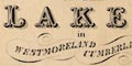
A NEW MAP OF THE LAKES, in WESTMORELAND CUMBERLAND &c. The map has lost its bottom edge, which may have had map maker and engraver information. |
|
|
|
||
|
orientation
compass rose up is N |
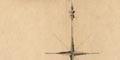
Printed upper left is a compass rose; no circle, star points for cardinal, and lines for half cardinal directions, North marked by a fleur de lys, South marked by an arrow. The map is printed with North at the top of the sheet. |
|
|
|
||
|
scale line
scale |
Printed lower left below the title is a scale line
of:-
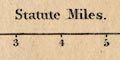
Statute Miles divided and labelled in miles. The 8 miles = 51.3 mm gives a scale 1 to 250970. The map scale is about:- 1 to 250000 4 miles to 1 inch |
|
|
|
||
|
lat and long
lat and long scales |
The border lines have labelled marks at 5 minute intervals, scales of latitude and longitude, for a trapezoidal projection. The map includes from about 2d 17m to 3d 6m W, from 53d 59m to 55d 9m N; most of Westmorland and Cumberland, and Lancashire North of the Sands, and a little bit of Yorkshire, etc. |
|
|
|
||
|
sea area
sea plain |
The sea area is plain, with some areas labelled, eg:-
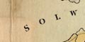
SOLWAY FIRTH IRISH SEA Wampool Bay |
|
|
|
||
|
coast line
coast tinted headlands harbours sands lighthouses |
The coast line is emphasised by a blue tint (now faded to a shade of green). Some headlands are labelled, eg:- Grune Point St. Bees Head Some harbours are noticed, eg:- Harrington Harb. and others are recognisable, for example at Whitehaven. 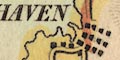
Foreshore sands are not marked, but notice the sands roads across Kent, Leven, and Duddon Estuaries. One area is labelled:- Lancaster Sands A tower of St Bees Head is labelled:- 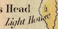
Light House and at the south tip of Walney Island is:- Light Ho. |
|
|
|
||
|
rivers
bridges |
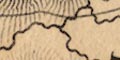
Rivers are drawn by wiggly line tapering upstream. Many rivers and tributaries are shown, some labelled, eg:- R. Derwent Caldew R. A broad stream, the Leven out of Windermere for instance, might be drawn by wider with a grey line. A waterfall might be labelled, eg:- Colwith Force Low Dore Waterfall Bridges are implied where a road crosses and interrupts a stream. Some are labelled, eg:- 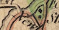
Newby Bridge Pooley Br. Bowdray Bridge South of Alston a waterfall is marked by two lines across the stream, labelled:- 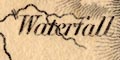
Waterfall and some other falls are named, eg:- Scale Force Colwith Force |
|
|
|
||
| lakes |
Lakes are drawn in outline, larger lakes tinted blue,
others with the area pecked. Some are labelled:-
Bassenthwaite W. [blue] Brothers Water Buttermere Wr. [blue] Coniston Water [blue] Crummock Water [blue] Derwent Water [blue] Eastwaite Water [blue] Elter Water [blue] Ennerdale Wr. [blue] Grasmere Lake [blue] 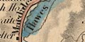
Hawes W. [blue] Kent Mere Tarn [blue] Kings Water [NE of Brampton] Lowes W. [blue] Over Water [SW of Uldale] Sparkling Tarn Sunbiggin Tarn Talkin Tarn Thirle Water [blue] 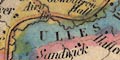
ULLES WATER [blue] Wast Water [blue] WINDERMERE [blue] others might be recognised, eg:- decoy pond [Lowther] Rydal Water [run into Grasmere] Skeggles Water Whinfell Tarn (?) etc. |
|
|
|
||
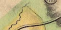
|
relief
hill hachuring |
Relief is indicated by hill hachuring. Some hills are
labelled, eg:-
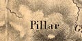
Pillar Saddleback Cross Fell Sca Fell Cold Peak A valley might be labelled, eg:- Sleddale [Wet Sleddale] While bigger hills are more heavily hachured, giving some sense of size, the overall effect suggests hilliness in the central Lake District and the Pennines, and no more. |
|
|
|
||
| beacons |
At least to beacons are noticed. On the hill north of
Penrith is a drawing of a tower, labelled:-
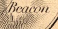
Beacon and on the south side of Thackmoor Fell, NE of Kirk Oswald, is:- Daffenside Beacon |
|
|
|
||
| forests |
Woodland is not indicated, but some forest areas are
labelled, eg:-
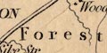
Westward Forest NICHOL FOREST |
|
|
|
||
| parks |
Some parks are drawn in outline, with fence palings.
Where another feature, perhaps a river, is the boundary the
fence palings are not shown. The park might be labelled, or
named by a great house, eg:-
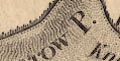
Gowbarrow P. High Park Brougham Hall |
|
|
|
||
| county |
County boundaries are a fine dotted line, except where another feature is used, a river perhaps. Each county has a tint along the inside of its boundary; Westmorland red, Cumberland yellow, Northumberland green, Yorkshire yellow, Lancashire green. The county areas are labelled, eg:- WESTMORELAND CUMBERLANDCOMMENT3 The northern tip of Cumberland, and the eastern parts of Westmorland are cut off from this map of the lakes area; this is not a county map. Notice the hill on the county boundary WNW of Alston called:- Meerlaw Hill |
|
|
|
||
|
settlements
town walls |
Settlements are marked by blocks or groups of blocks,
perhaps a cross (+) for a church, differentiated by style of
labelling.
|
|
| cities |
group of blocks; labelled in upright block caps, eg:-
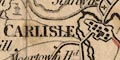
CARLISLE The town wall is clearly shown here. |
|
| towns |
groups of blocks, perhaps a cross; labelled in italic
block caps, eg:-
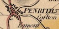
PENRITH AMBLESIDE ORTON but notice:- 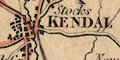
KENDAL APPLEBY in upright caps as the de facto and de jure county towns. The blocks and roads might be arranged as a street plan, as at Kendal and Penrith. Some of the places shown as towns might not have been market towns? |
|
| villages |
blocks, perhaps a cross; labelled in upright lowercase
text, eg:-
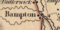
Bampton Gt. Asby Natland |
|
| hamlets |
block or blocks, perhaps a cross which does not
necessarily mean a parish; labelled in italic lowercase
text, eg:-
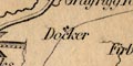
Docker Stockdale Knip |
|
|
The interpretation as city, town, village, hamlet, is
uncertain. The last style of lettering is used generally for
various features on the map.
|
||
|
|
||
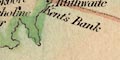
|
roads
sands roads |
A network of roads is drawn by double line, bold light, some tinted red, and by single line. The sands roads are drawn by a dotted line, with red tint. From Hest Bank to Kents Bank across Lancaster Sands; and the:- Guides House labelled just up the coast. Across the Leven Sands; and on the Ulverston coast is:- 
Carters House |
|
|
|
||
| canals |
Canals are drawn by triple line, light bold light. The
following canals are shown:-
|
|
| Ulverston Canal |
from near Ulverston to the coast.
|
|
| Lancaster Canal |
from south of Lancaster, close round the city, to Kendal. And branches: from about Borwick, to Walton; and from Galgate to the Lune Estuary. |
|
|
|
||
| miscellaneous | ||
|
|
||
|
mines
coal mines lead mines |
SE of Hornby, Lancashire, is a label:-
Coal Pits On the west side of Derwent Water is:- 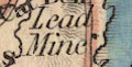
Lead Mine |
|
|
|
||
|
quarries
slate quarries |
At the head of the Troutbeck Valley is:-
Slate Quarry which could be the quarry in Kentmere Valley? And south of Skelwith is:- Flag Quarry |
|
|
|
||
| inns |
Some inns are noticed, eg:-
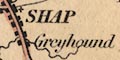
Greyhound [Shap] Royal Oak [NE of Caldbeck] Castle Inn [near Armathwaite Hall] |
|
|
|
||
| stones |
Some stones are labelled, eg:-
Dunmail Raise Stones Bowderstone Hollin Stone [? SE of Bampton] |
|
|
|
||
| caves |
Notice:-
Douk Cave on Ingleborough. |
|
|
|
||
| crosses |
A cross symbol NE of Melmerby is labelled:-
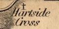
Hartside Cross And a pillar is drawn labelled:- 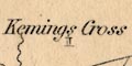
Kemings Cross in Northumberland. |
|
|
|
||
|
antiquities
stone circles |
A circle marks the Castlerigg Stone Circle,
labelled:-
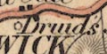
Druids Circle And:- Arthurs Round Table is labelled. |
|
|
|
||
|
antiquities
roman sites roman forts roman roads roman wall |
Hadrian's Wall is marked by a broad grey line, shaded at
the bottom, from Bowness, past Carlisle and eastward into
Northumberland.
A tower with a flag, south of Kirkandrews is labelled:- 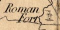
Roman Fort There are square symbols with four wings, which remind of another map's symbols for forts, labelled:- 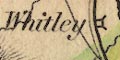
Whitley [NW of Alston] Magna Greenwheel [NW of Haltwhistle] A roman road:- Maiden way is drawn from Milburn Grange near Kirkby Thore, across Cross Fell to near Alston. There are place names in Latin, eg:- Gallatum [S of Kirkby Thore] Voreda [N of Plumpton Wall] |
|
Lakes Guides menu.