 Jenner 1643

|

|
|

|
back to object record | |
| MAP FEATURES | ||
|
|
||
| title |
Printed in the space at top left of the triangular table of distances is:- Westmer / land. |
|
|
|
||
|
orientation
up is N up is NE |
There is no indicator of orientation. The map, tucked in
the bottom right space of the triangular table, is printed
with NE at the top of the sheet. But the labelling is
arranged to read with North at the top.
|
|
|
|
||
|
scale line
scale dividers |
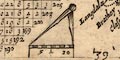
Printed with the map is a scale line; chequered in miles, labelled 5 and 10. The 10 miles = 15.6 mm gives a map scale 1 to 1031631, wrongly assuming a statute mile. The map scale is about:- 1 to 1000000 16 miles to 1 inch A pair of dividers is fitted in as well as can be. |
|
|
|
||
| rivers |
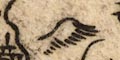
A few rivers are drawn by wiggly line tapering upstream.
It is possible to recognise:-
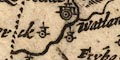
Kent, River Lune, River Eden, River and some tributary streams. |
|
|
|
||
| lakes |
The north part of:-
Windermere can be recognised, drawn in outline, shaded; but no other lakes. |
|
|
|
||
|
relief
hillocks |
Two hillocks, shaded to the east, indicate relief in the county. One is north of Kendal, the other NW of Appleby. |
|
|
|
||
| county |
The county boundary is a dotted line. A few places are plotted outwith the county, using up the available space. |
|
|
|
||
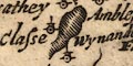
| settlements |
Settlements are positioned by a dot and circle or double
circle, with added elements, slightly differentiated by
style of labelling.
It is possible to allocate a perceived importance of places based on their mapping. The notes below use the terms town and village in an unreliable way! |
|
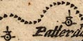
| towns |
dot and two circles, buildings? and a tower; labelled in
italic lowercase lettering, eg:-
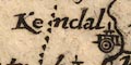
Kendal Kirkbye Steven |
|
| villages |
dot and circle, a tower; labelled in smaller italic
lowercase text, eg:-
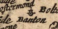
Banton [Bampton] Watland [Natland] Ambleside |
|
| Table of Distances | ||
|
The map is only an added feature to a triangular table of
distances.
|
||
|
Places are listed is an arbitrary order top to bottom of the
left side of the table, with a letter indicating where the
place is in the county; it might not be on the map, eg:-
|
||
|
Appleby. N.
|
||
|
Gresmere. N.W.
|
||
|
Places, minus one, are listed across the top of the table
from right to left. Entries in the table fill the upper left
triangle. The main diagonal, running top left to bottom
right, is used to record the distance of places from London.
|
||
|
|
||
| settlements |
Using both column and row to check spellings, the places
listed in the table are, in table order:-
Temple Sowerby N. Kirkland N. Midleton E. Firbancke E. Orton N. Langdale N. Fawsetwood N. Levens bridge S. Betham S. New bridge S.E. Ambleside N.W. Hawkside W. Gresmere N.W. Harteshope Hall N. Banton N. Crostermonde N. Browgham Ca: N. Stricklands N. Crosby Ravensw: N. Appleby N. Helton N. Burgh Castle N. Great Musgrave N. Kirkby Steven N. Pendragon Ca: E. Kirkby Landall S. |
|
Lakes Guides menu.