 Cowley 1743

|

|
|

|
back to object record | |
| MAP FEATURES | ||
|
|
||
|
title cartouche
drape cartouche map maker |
Printed in a drape cartouche lower right:-
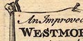
An Improved MAP of WESTMORELAND containing the Borough and Market Towns with those adjoyning; also, its Principal Roads and Rivers by I. Cowley Geor. to his MAJESTY As well as being draped on two posts the title cloth is pinned up in the middle. The paper has a water mark, part of a fleur de lys? |
|
|
|
||
|
orientation
compass rose up is N |
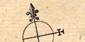
Printed upper left is a minimal compass rose; circle, lines for the cardinal directions, North marked by a fleur de lys, East marked by a cross. The N-S line is parallel the meridian direction given by the scales of longitude top and bottom, this is a few degrees west of north. Roughly, the map is printed with North at the top of the sheet. |
|
|
|
||
|
scale line
scale |
Printed lower middle is:-
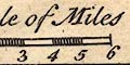
A Scale of Miles chequered and labelled in miles. The 6 miles = 27.9 mm gives a scale 1 to 346095 wrongly assuming a statute mile. The map scale is about:- 1 to 350000 5.5 miles to 1 inch |
|
|
|
||
| lat and long scales |
Printed in the map borders are scales of latitude and longitude for a slanted rectangular projection; chequered at 2 minute intervals, labelled at 10 minute intervals. As there is no degree parallel across Westmorland there is a helpful label in the left border:- Lat 54 Degrees and the bottom scale is labelled:- Degrees W. Longitude from London. From the longitude scales the longitude, Kendal = 2d 24m which suggest a prime meridian 20 minutes west of Greenwich, which seems unlikely. |
|
|
|
||
| table of symbols |
Printed lower left is an:-
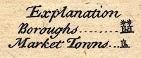
Explanation Boroughs ... [circle, two towers, asterisk(s)] Market Towns ... [circle, tower] |
|
|
|
||
|
sea area
sea plain |
What little sea is shown is plain.
|
|
|
|
||
|
coast line
coast shaded |
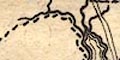
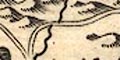
The coast of the Leven and Kent estuaries is shaded for emphasis, two levels of shading. In the narrower part of the estuary the river banks are drawn with form lines. |
|
|
|
||
|
rivers
bridges |
Broader, lower, parts of rivers are drawn by a double line with form or stream lines. Narrower, higher, stretches are drawn by a single wiggly line which tapers at the head. Some rivers are labelled, eg:- Can R. [Kent] Eymot R. [Eamont] Bridges are implied where a road crosses and interrupts a stream. But a bridge might also be marked by a double line, a stretch of road not attached to the road network, over a river, as at Kirkby Lonsdale, and, labelled, at:- 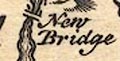
New Bridge [Newby Bridge] Burrow Bridge [Low Borrow Bridge] and elsewhere. |
|
|
|
||
| lakes |
Lakes are drawn in outline with form lines. Their shapes
and sizes are not reliable guides to reality. Some are
labelled, also unreliably:-
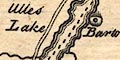
Ulles Lake Broad Water [Hawes Water] Minander Mere [Kentmere tarn though a village might be meant] Winander Mere It is possible to recognise, or guess at others:- Brothers Water Hayes Water Grasmere Easdale Tarn Coniston Water |
|
|
|
||
|
relief
hillocks |
Relief is indicated by groups of hillocks. The grouping
is not very helpful in understanding the hilliness of the
country. One or two hills are labelled, eg:-
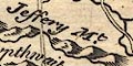
Jeffery Mt. Whinfield Hill [Whinfell] |
|
|
|
||
| forests |
Woodland is not indicated, but some forest areas are
labelled, eg:-
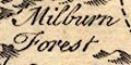
Milburn Forest Thorpthwaite Forest |
|
|
|
||
| parks |
Parks are drawn by a roundish outline with fence palings.
Only one? is labelled:-
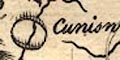
Cuniswick P. though one or two others might be recognised. |
|
|
|
||
| county |
The county boundary is a dashed line which is continued by other features which marek a boundary. Adjacent counties are labelled, eg:- P. of CUMBERLAND Part of YORK SHIRE Very little is drawn outwith the county; Penrith, a few hillocks by Windermere, for examples. |
|
|
|
||
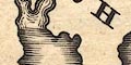
| settlements |
Settlements are marked by a circle with added elements,
differentiated by style of labelling.
|
|
| towns |
circle, one or two towers; labelled in upright lowercase
text or italic block caps. Two towers and caps for a borough
town, the number of member returned to Parliament shown by
asterisks:-
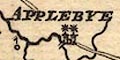
APPLEBYE [circle, two towers, two asterisks] one tower and lowercase text for a market town, eg:- 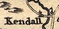
Kendall Ambleside Shap |
|
| villages |
circle; labelled in italic lowercase text, eg:-
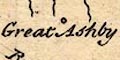
Great Ashby Witherslack Barton |
|
| castles |
circle with a flag, labelled as at:-
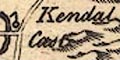
Kendal Cast. Buley Cast. [W of Appleby] |
|
|
|
||
| roads |
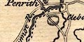
A network of main roads is drawn by double lines. Destinations are marked at the county boundary, eg:- to Cockermouth to Lancaster The routes shown are interesting:- from the south, Lancashire; through Burton, by Kendal, over the Kent and Sprint, through the mountains, perhaps over High Borrow Bridge, then Shap, across the Lowther and Eamont, Westmorland; to Penrith, and north west, Cumberland. alternative from Kendal, over Low Borrow Bridge, near Orton, to join the other north-south route south of Shap, Westmorland. branch from Kendal, through Ambleside, beside Rydal Water and Grasmere, Westmorland; into Cumberland, towards Cockermouth. branch from Ambleside, over the Kirkstone Pass, beside Ullswater, Westmorland; into Cumberland to Penrith. from Durham and/or Yorkshire; through or by Brough, then Appleby, Westmorland; to Penrith, Cumberland. branch north labelled:- Maiden Way Some road distances between towns are given by figures by a road segment. For example Burton-Kendal 8, Kendal-Shap 13, Shap-Penrith 5. |
|
Lakes Guides menu.