 Cooke 1802

|

|
|

|
back to object record | |
| MAP FEATURES | ||
|
|
||
|
title cartouche
plain cartouche engraver |
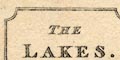
Printed upper left in a plain cartouche is:- THE LAKES Printed bottom right is:- Neele and Son [Co] Strand. |
|
|
|
||
|
orientation
up is N |
The map is printed with North at the top of the
sheet.
|
|
|
|
||
|
scale line
scale |
Printed lower left is a:-
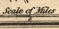
Scale of Miles chequered in miles to 5, then in 5 mile intervals. The 10 miles = 29.9 mm gives a scale 1 to 538242 assuming a statute mile. The map scale is about:- 1 to 540000 8.5 miles to 1 inch |
|
|
|
||
|
sea area
sea plain |
The sea area west of Cumberland is plain, labelled:-
IRISH SEA |
|
|
|
||
|
coast line
coast shaded headlands |
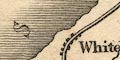
The coast line is shaded for emphasis. One headland is labelled:- St. Bees Heads |
|
|
|
||
|
rivers
bridges ferries |
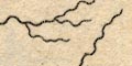
Rivers are drawn by a wiggly line tapering upstream. Some rivers are labelled, eg:- Ken R. Cocker R. Bridges are implied where a road crosses and interrupts a stream. |
|
|
|
||
|
relief
hillocks hill hachuring |
Some relief is indicated by a scatter of hillocks, some
labelled, eg:-
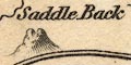
Saddle Back Skiddow H Bell Black Comb A few peaks are shown by a ring of hill hachures, eg: 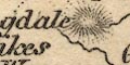
Langdale Pikes High Pike Eagle Craggs and without any symbol is:- Borrowdale Fells |
|
|
|
||
| lakes |
Lakes are drawn in outline with form lines. Many are
labelled:-
Bassenthwaite Water Broad W. [Brothers Water] Burnmoor Tarn Buttermere Coniston W. Crommock Water Derwent Water Devock Lake Easthwaite W. Elter water Ennerdale W. Goats Tarn Grasmere Haws Water Kentmere Tarn Leaths W. [Thirlemere] Lever Water Lows Water Over Water Rydal Skeggles Water 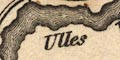
Ulles Water Waste Water Winandermere and a few more can be recognised:- Codale Tarn (?) Easedale Tarn Notice that a river is shown connecting Thirlmere to Grasmere over Dunmail Raise. |
|
|
|
||
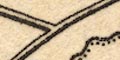
| county |
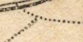
The county boundaries are a dotted line. the county areas are labelled:- WESTMORELAND CUMBERLAND LANCASHIRE |
|
|
|
||
| settlements |
Settlements are marked by blocks, differentiated by style
of labelling.
|
|
| cities |
blocks, in rows; labelled in upright block caps:-
CARLISLE |
|
| towns |
blocks; labelled in upright lowercase text, eg:-
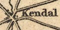
Kendal Ambleside Cockermouth |
|
|
villages
hamlets |
blocks; labelled in italic lowercase text, eg:-
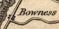
Bowness Shap Graystock |
|
|
An area might be labelled, as:-
Longsleddale but it is not clear whether this is the physical valley or the valley community. |
||
|
|
||
| roads |
A network of roads is drawn by double line, light bold. |
|
|
|
||
| miscellaneous | ||
|
|
||
| stones |
perhaps marked by a block are, labelled:-
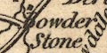
Bowder Stone Dunmail Raise Stones |
|
|
|
||
| stations |
Unusually, on a small map, one of Thomas West's many
stations is labelled:-
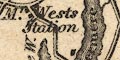
Mr. West's Station probably referring to the block on the west side of Windermere, near the ferry road. |
|
Lakes Guides menu.