 Collins 1693

|

|
|

|
back to object record | |
| MAP FEATURES | ||
|
|
||
|
dedication
pictorial cartouche coat of arms |
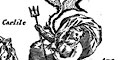
Printed in a scroll cartouche lower right, decorated with Neptune, horses, coat of arms, etc, is a dedication:- To the Honble. SR. JOHN LOWTHER Bart. On of the Commissioners / for Executing the Office of Lord High Admiral of England The coat of arms in the cartouche is of the Lowther Family. |
|
|
|
||
|
orientation
compass rose up is W rhumb lines |
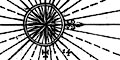
Printed in the middle of the chart, in the Irish Sea between the Isle of Man and the mainland is a compass rose; circle, star points for cardinal, half cardinal and false points, lines for by points, North marked by a fleur de lys, East marked by a cross. The chart is printed with West at the top of the sheet. There rhumb lines from the compass over all the sea area; bold lines for cardinal directions, light for half cardinal, dotted for false points. |
|
|
|
||
|
scale
scale line scale line |
Printed lower right is:-
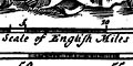
A Scale of English Miles chequered in miles to 5 then in tens. The 15 nautical miles = 60.3 mm gives a scale 1 to 460991 assuming a 'standard' nautical mile. The map scale is about:- 1 to 460000 ? 6.5 nautical miles to 1 inch |
|
|
|
||
| latitude scales |
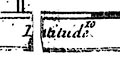
Printed in the top and bottom, ie west and east, borders are scales of latitude; chequered and labelled at 5 minute intervals. |
|
|
|
||
|
sea area
sea plain sandbanks depth soundings galleons |
The sea areas is plain. Depth soundings are given in fathoms; these are scattered over the chart though it is possible to see some lines of soundings, for example westward from St Bees Head. Sandbanks are shown by dotted areas, with a double line of dots around the edge. There might be relevant depth soundings, and a sandbank might be labelled, eg:- 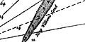
King Williams Sand Hyle Sand 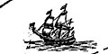
A couple of ships are shown. One of these, for example, off Kirkcumbrick, is a three masted ship; sprit with small mast, fore mast with main and top sails, main mast with a furled main and a top sail, mizzen mast with a lateen sail and a yard for a top sail. The hull appears to be black and white with a row of at least four gun ports, perhaps a naval vessel. It is possible to imagine a large lantern at the stern. |
|
|
|
||
|
coast line
coast shaded foreshore sandbanks headlands anchorages leading lines coast appearance |
The coast line is emphasized by shading on the landward side, framing the sea. Contrast this with land maps which have coast shading in the offing, framing the land. Foreshore sands and sandbanks are indicated by dotting, the boundary a double row of bolder dots. Some shallows are labelled, eg:- 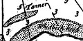
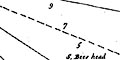
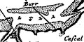
Tanner Burr Ken Sands Lancaster Sands The large bay of Moricambe can be recognized in north Cumberland. Some headlands are labelled, eg:- S. Bees head Whidbeck head 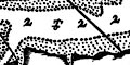
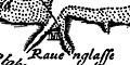
Anchorages might be marked by an anchor symbol, as in the roads off Ravenglass, and between the Great Orme and Chester Bar, where is also a cluster of depth soundings. 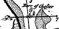
Leading lines are drawn to help navigate the approach into the channel below Chester. One runs from Little Orme Head to a point in the channel of the River Dee (where there might be buoy). The other runs N-S from '3 Hills'. The intersection helps locate the shallows of the:- Barr of Chester Notice some labelled channels, eg:- Hyle Lake Formby Channel Inset at the lower left and middle are outline views of parts of the coast from the sea:- ... Thus sheweth Great and Little Orme head when you go over the best of Chester Barr and:- Thus sheweth the 3 Hills when you are on the shoalest of Chester barr, the 3 Hills bear So. 3 Hills labels three hillocks drawn on the land as sea marks. |
|
|
|
||
| rivers |
Only river estuaries indicate rivers. As is usual with sea charts the landward topography is mostly ignored unless it has some relevance to the mariner. In Cumberland it is possible to recognize the Lune and Kent estuaries, the Duddon estuary, an inlet at Ravenglass but not three separate rivers, and other small inlets up to Solway. The only river named is:- Mersey R. |
|
|
|
||
| relief |
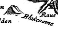
The only hill shown in Cumberland a large hillock, shaded to the left, ie south, labelled:- Blakcoome |
|
|
|
||
| county |
County boundaries are not shown. A county or country
names are printed on land areas, eg:-
CUMBERLAND SCOTLAND |
|
|
|
||
| settlements |
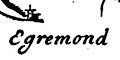
A few coastal settlements are marked by a dot with added elements. In Cumberland from south to north are:- |
|
| Sailing Directions | ||
|
The sailing directions relevant to this sheet are on page 8
(1753 edition) and for Cumbria only have:-
|
||
|
White Haven / A little to the northward of St. Bees Head
lieth White Haven, being a good dry Pier, where great Ships
take in Sea-Coals, and carry them to Dublin in Ireland. This
place belongeth to Sir John Lowther. / ...
|
||
Lakes Guides menu.