 Cary 1787

|

|
|

|
back to object record | |
| Map Features | ||
|
The notes are slightly biased towards Westmorland. The
series of maps includes Westmorland, Cumberland and the
surrounding counties of Northumberland, Durham, North
Yorkshire, Part of the West Riding of Yorkshire, and
Lancashire.
|
||
|
|
||
|
title
compass rose cartouche |
Printed lower right, in and below the plain title
cartouche with the compass rose:-
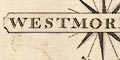
WESTMORELAND / By JOHN CARY Engraver and at the bottom:- London: Published as the Act directs Septr. 1st. 1787 by J. Cary, Engraver, Map & Print-seller, the corner of Arundel Street Strand. and printed similarly:- CUMBERLAND / By JOHN CARY Engraver and similarly at the bottom. |
|
|
|
||
|
orientation
compass rose up is N |
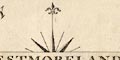
Printed lower right, combined with the title cartouche, is a compass rose; star points for the cardinal and half cardinal directions, lines for the by points, North is marked by a fleur de lys spearpoint. The map is printed with North at the top. |
|
|
|
||
|
scale line
scale |
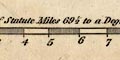
Printed lower right of each map is a:- Scale of Statute Miles 69 1/2 to a Degree Westmorland has 10 miles = 50.3 mm giving a scale 1 to 319949. The map scale is about:- 1 to 320000 5 miles to 1 inch Cumberland has 10 miles = 38.3 mm. The map scale is about :- 1 to 420000 6.5 miles to 1 inch |
|
|
|
||
| lat and long scales |
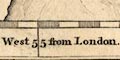
Printed in the map borders are scale of latitude and longitude for a rectangular projection; chequered in minutes, labelled at minute intervals. The bottom scale is labelled:- Longitude West from London Beware, on both maps, that the 3 degree meridian is labelled 'II'. The Westmorland map includes from 2d 4m to 3d 15m W, from 54d 11m to 54d 44m N; all of Westmorland. The Cumberland map includes from 2d 16m to 3d 31m W, from 54d 6m to 54d 56m N; all of Cumberland. From the scales the Longitude, Kendal = 2d 44.5m W suggesting a prime meridian at Greenwich. |
|
|
|
||
|
sea area
sea plain |
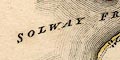
The sea area is plain; a few areas are labelled, eg:- IRISH SEA SOLWAY FRITH or EDEN R |
|
|
|
||
|
coast line
coast form lines lighthouses |
The coast line is emphasized by form lines. A ?tower is marked on St Bees Head, labelled:- 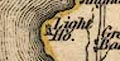
Light Ho. |
|
|
|
||
|
rivers
bridges |
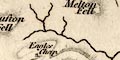
Rivers are drawn by a wiggly line tapering upstream. A few rivers are labelled, eg:- Lune R Emont R Tees Riv. Kings Water 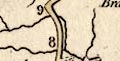
Bridges are implied where a road crosses and interrupts a stream, but are not general labelled; but see:- Duddon Br. It is possible to recognize some bridges; for instance, at Kendal, Mint Bridge, Stramongate Bridge and Nether Bridge. |
|
|
|
||
| lakes |
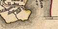
Lakes are drawn by an outline with form lines. The following lakes are labelled in Westmorland, Cumberland and Lancashire:- Bassenthwaite Water Broad Water (Brothers Water) Burnmoor Tarn Buttermire Water Coniston Water Crummock Water DERWENT WATER (with 5 islands) Devock Lake Ennerdale Water Greencastle Tarn Horns Water (Hawes Water) Lowes Water Over Water Skeggles Water Tarn Wadling Thirle Mere Tindale Tarn ULLES WATER Wast Water WINANDER MERE (with Belle Isle and a couple of other islands) Other lakes or tarns might be recognized, with some difficulties, eg:- Blea Tarn, Eskdale (?) Bleaberry Tarn Cardurnock Lough Cunswick Tarn decoy pond, Lowther Easedale Tarn Fisher Tarn Reservoir (?) Floutern Tarn (?) Grasmere lake Grisedale Tarn Hayes Water Kentmere Tarn Little Tarn (?) Ponsonby Tarn (?) Red Tarn, Patterdale Rydal Water Scales Tarn Stickle Tarn (?) Styhead Tarn Watendlath Tarn (?) Whinfell Tarn Whins Pond unidentified, near Rockliffe |
|
|
|
||
|
relief
hill hachuring beacons |
Some relief is suggested by hill hachuring, but this seems more to fill blank spaces than to show the shape of the district. Some heights are labelled, eg:- Mickle Fell Helvelein High Street Crow Brow (Ancrow Brow) Harter Fell Oddendale Knab Some vallies are labelled as areas, sometimes lying between hill hachures, eg:- Martindale Dibdale (Deepdale) Whinfell Beacon is labelled:- Beacon North of Penrith is:- 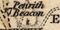
Penrith Beacon |
|
|
|
||
|
woods
trees forests |
Woodland is suggested by tree and bush symbols within parks, bot otherwise in only a few instances. There is an example NE of Appleby. Some forest areas are labelled, eg:- 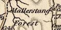
Mallerstang Forest Stainmoor Forest An individual tree might be marked, and labelled, eg:- 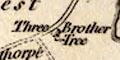
Three Brother Tree north of Cliburn, and Shap Thorn on Shap Fell. |
|
|
|
||
| parks |
Parks are drawn by an outline with fence palings, the
interior perhaps having a suggestion of vegetation, and
tinted green. A park might be named, eg:-
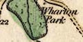
Wharton Park Trogtbeck Park (Troutbeck Park) |
|
|
|
||
| county |
County boundaries are a dashed line, generally continued alongside a border feature like a river. On the example maps the borders are narrowly tinted along with a colour for the county, one colour each side of the line. On the Westmorland map the colours are: Westmorland yellow; Cumberland green; Durham red; Yorkshire green; Lancashire red, except the Kent Estuary which has green. The boundary between adjacent counties might be drawn, but where not the colour change is a clue. Windermere lake is confused. The boundary leaving the east shore is placed correctly but coloured to suggest neither Westmorland or Lancashire. The Ullswater boundary is drawn and coloured correctly. Some boundary features are clearly included, for examples: the County Stone and Mickle Fell, on Westmorland, and, on the Cumberland map only, the Three Shire Stones. Cumberland has a yellow tint, which is continued along the sea coast; Scotland red, Northumberland green, Durham red, Westmorland green, Lancashire red. None of the colours has any 'meaning'. Very little is shown outwith the county of each map. Adjacent counties are labelled, eg, on Westmorland:- CUMBERLAND LANCASHIRE |
|
|
|
||
| settlements |
Settlements are marked by blocks, differentiated by style
of labelling.
|
|
|
cities
electoral data |
blocks, tinted red; labelled in upright block caps,
eg:-
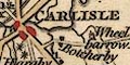
CARLISLE |
|
|
There are two stars attached indicating it returns two
members to Parliament.
|
||
|
towns
street plan electoral data |
blocks; labelled in upright block caps, eg:-
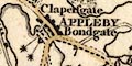
APPLEBY ORTON Appleby has two stars attached indicating it returns two members to Parliament. The de facto county town:- 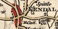
KENDAL has a red tint, and is large enough to show a minimal street plan. |
|
| villages |
blocks, perhaps a cross for a church; labelled in upright
lowercase text, eg:-
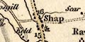
Shap Bampton Milnthorpe |
|
| hamlet |
block or blocks, perhaps a cross for a church; labelled
in italic lowercase text, eg:-
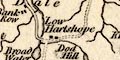
Low Hartsope Askham |
|
|
The differentiation between the categories is
uncertain.
|
||
|
houses
castles |
Houses and castles are drawn by a building, generally
labelled in italic lowercase text, eg:-
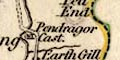
Pendragor Cast. Levens Hall |
|
|
|
||
|
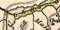
roads
road distances |
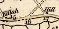
A network of roads is drawn by double lines, solid and dotted possible for fenced and unfenced roads, or just to show wilder parts? The roads are broader or narrower for importance, and some have one line bolder. These latter might have distances numbered alongside, on the Westmorland map the distances are counted out from Kendal, except where this is not possible. At the county boundary a road might be labelled with its destination, eg:- 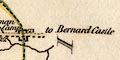
to Barnard Castle from Lancaster The main roads of Westmorland are, using the numbering as a guide:- Kendal, through Milnthorpe, Westmorland; 'from Lancaster', Lancashire Kendal, through Burton-in-Kendal, Westmorland; 'from Lancaster', Lancashire Kendal, through Kirkby Lonsdale, Westmorland; 'from Lancaster', Lancashire from Kirkby Lonsdale, Westmorland; 'to Settle', Yorkshire from Kirkby Lonsdale, Westmorland; to Sedbergh, Yorkshire from Kendal, Westmorland; to Sedbergh, Yorkshire from Sedbergh, Yorkshire; to Kirkby Stephen, Westmorland from Kendal, through Tebay, Orton, to Appleby, Westmorland AND a branch from Tebay, through Kirkby Stephen, to Brough, Westmorland from Kirkby Stephen, through Nateby, Westmorland; 'to Richmond', Yorkshire from Brough, Westmorland; 'to Barnard Castle', Durham from Brough, through Appleby, Temple Sowerby, Westmorland; to Penrith, Cumberland from Kendal, through Shap, Westmorland; to Penrith, Cumberland from Kendal, through Crosthwaite, Westmorland; into Lancashire from Kendal, through Staveley, Ambleside, near Grasmere, Westmorland; 'from Cockermouth', Cumberland The main roads of Cumberland are, using the numbering as a guide:- from Penrith, Cumberland; through Eamont Bridge, 'to Brough', Westmorland from Carlisle, through High Hesket, to Penrith, Cumberland from Carlisle, through Low Crosby, Brampton, Cumberland; 'to Newcastle', Northumberland from Carlisle, through Longtown, Cumberland; 'to Edinburgh by Kelso', Scotland from Carlisle, through Dalston, to Uldale, Cumberland from Cockermouth, through Uldale, Hesket Newmarket, Hutton, to Penrith, Cumberland presumably from Penrith, numbered from a junction beyond Skelton, through Sebergahm, to Wigton, Cumberland from Maryport, through Allonby, to the Wampool Estuary, Cumberland from Workington, to Maryport, Cumberland from Cockermouth, through Clifton, with a link to Workington, then Distington, to Whitehaven, Cumberland from Cockermouth, through Bassenthwaite, to Keswick, Cumberland from Whitehaven, through Egremont, to Ravenglass, Cumberland from Ravenglass, through Bootle, Millom, to the Duddon Estuary, Cumberland from Keswick, but numbered further north, through Wythburn, Cumberland; 'to Kendal', Westmorland |
|
|
|
||
| miscellaneous | ||
|
|
||
| inns |
A few inns are labelled, for example the:-
Punch Bowl on Stainmoor. |
|
|
|
||
|
mines
lead mines coal mines |
Three dots by Dufton Fell are labelled:-
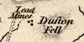
Lead Mines On a track east from Talkin are three dots labelled:- Coal Pits |
|
|
|
||
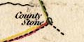
| stones |
At the meet of Westmorland, Lancashire and Yorkshire is
the:-
County Stone At the meet of Westmorland, Cumberland and Lancashire are the:- 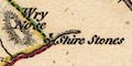
Shire Stones on the Cumberland map only. |
|
|
|
||
| monuments |
On the coast of the Solway is:-
Edw I. Monum |
|
|
|
||
|
antiquities
earthworks |
NW of Rey Cross is:-
Maiden castle |
|
|
|
||
|
antiquities
roman roads roman forts roman wall |
The road between Brough and Appleby is labelled:-
Roman Way and across the foot of Cross Fell is:- Maiden Way At Rey Cross four walls of a roman fort lie across the road and county boundary, labelled:- 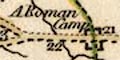
A Roman Camp A line from Bowness, through Carlisle, then NE and E into Northumberland, is labelled:- 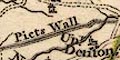
Picts Wall |
|
Lakes Guides menu.