 Bowles 1785

|

|
|

|
back to object record | |
| Map Features | ||
|
|
||
| title |
Printed at the top in a plain title cartouche with
decorative scroll ends:-
BOWLES'S REDUCED MAP OF WESTMORELAND. and notice the plate number 53 top right. |
|
|
|
||
| table of symbols |
Printed lower right are:-
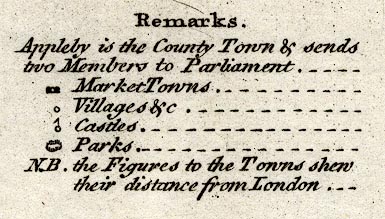
Remarks Appleby is the County Town & sends two Members to Parliament. [block circle block] Market Towns. [circle] Villages &c. [circle and flag] Castles. [ring of fence palings] Parks. N.B. The Figures to the Towns shew their distance from London. |
|
|
|
||
|
orientation
compass rose up is N |
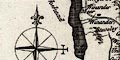
Printed on the left side is a compass rose; circle, stars points for cardinal directions, lines for half cardinal directions, North marked by a fleur de lys sprearpoint, East marked by a cross paty. The map is printed with North at the top of the sheet. |
|
|
|
||
|
scale line
scale |
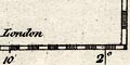
Printed upper left is a scale of:-
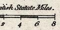
British Statute Miles. chequered for miles 1 and 2 then at 2 mile intervals. The 8 miles = 27.8 mm gives a scale 1 to 463121. The map scale is about:- 1 to 460000 7.5 miles to 1 inch |
|
|
|
||
|
lat and long scales
lat and long grid |
Printed in the map borders are scales of latitude and longitude for a ?slanted trapezoidal grid; chequered in minutes, labelled at 10 minute intervals. The map incudes from 1d 59m to 3d 21m W, from 54d 6m to 54d 44m N; the whole of Westmorland. The bottom scale is labelled:- Longitude West from London From the scale lines the longitude, Kendal = 2d 51.8m W which suggests a prime meridian 7 degrees E of Greenwich, which is unlikely. The latitudes shown do not include a whole degree mark so the right scale has a label:- Nth. Latd. 54D. 20min. by the 20 minute mark. |
|
|
|
||
|
coast line
coast shaded |
The small part of coast shown, in the Kent Estuary, is shaded for emphasis. |
|
|
|
||
|
rivers
bridges |
Rivers are drawn by a wiggly line tapering upstream. Some rivers are labelled, eg:- Ken or Can R. Eymot R. Glenk R. [Glencoyne Beck] Blenkernbec R. [Crowdundle Beck] Bridges are implied where a road crosses and interrupts a stream. But this is not reliable, for example, the Lune crosses the road without interruption at Kirkby Lonsdale where the bridge long predates the map. Few bridges are labelled, but see:- Pesa Bridge [Peasey Bridge] |
|
|
|
||
| lakes |
Lakes are drawn by an outline with the shore shaded. Some lakes are labelled:- Broad Water [Hawes Water] Haws Water [Hayes Water] Lake Ulles Winander Mere A few other lakes or tarns might be recognized, eg:- Kentmere Tarn |
|
|
|
||
|
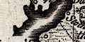
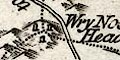
relief
hillocks |
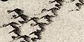
Little hillocks are scattered over the map to suggest hilly country. Some are in rows to suggest ranges of hills, but they are not to be trusted as indicators of the shape of the county. There are some labels, eg:- Gresmere Hill [Dunmail Raise] Wry Nose Head |
|
|
|
||
|
woods
forests |
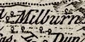
Some woodland is indicated by little tree symbols, but matching these to woods today is doubtful. Some forests are labelled, eg:- Stainmoor Forest Milburn Forest Both shown with trees. |
|
|
|
||
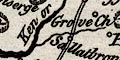
| parks |
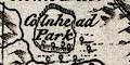
Parks are drawn by an outline of fence palings, the interior with a few trees. Some parks are labelled, eg:- Holme Park Colnhead Park |
|
|
|
||
| county |
The county boundary is a dotted line, continued along a boundary feature like a river. Notice that Windermere lake is excluded from Westmorland; the Ullswater part of the boundary is sort of correct, the shape of the lake is not. The Three Shire Stones are drawn on Wrynose but not labelled; a stone is drawn at the meet of Westmorland, Lancashire and Yorkshire, labelled:- County Stone Adjacent counties are labelled, eg:- CUMBERLAND LANCASHIRE but very little is drawn outwith the county. |
|
|
|
||
| settlements |
Settlements are marked by a circle with added elements,
differentiated by style of labelling.
|
|
|
towns
distances from London electoral data |
circle flanked by blocks for a market town; labelled in
upright lowercase text, eg:-
Ambleside / 262 1/4 Orton / 265 except the de jure county town, in italic block caps:- 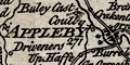
APPLEBY / 271 which has two stars attached for the two members it returns to Parliament. The figures are the distance from London. |
|
|
villages
towns hamlets |
circle; labelled in italic lowercase text, eg:-
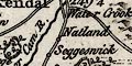
Natland Shapp or Shaw [Shap] Kentmere Rissendale [Ravenstonedale] |
|
| castles |
circle with a flag; labelled in italic lowercase text,
eg:-
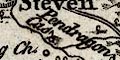
Pendragon Cas Haukul Castle [Hawking Hall, Middleton] but also:- Broom Cas. Kendal Castle both of which seems to have lost their flag. |
|
|
|
||
| roads |
A network of roads is drawn by a double line. Given the roads that are included it is worthy noticing some omissions - no road Kendal to Kirkby Stephen, no road Kendal to Sedbergh, no road beyond Patterdale around Ullswater, no road through Milnthorpe, for examples. Most roads are labelled with their destination, at the county boundary, eg:- to Lancaster to Carlisle These are engraved with the word up looked at with the county boundary to the left - ie upsidedown on the left of the map, etc. |
|
|
|
||
| miscellaneous | ||
|
|
||
|
antiquity
earthworks |
A ring of fence palings, like a park, at Eamont Bridge,
is labelled:-
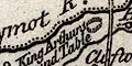
Kings Arthurs Round Table |
|
|
|
||
| well |
By Patterdale is:-
St. Patricks Well |
|
|
|
||
| stones |
Three stones are marked on Wrynose, but not labelled. A
stone shown at the meet of Westmorland, Lancashire and
Yorkshire is labelled:-
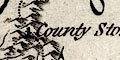
County Stone |
|
|
|
||
| peat moss |
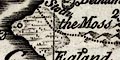
An area south of Storth, across the county boundary, is labelled:- The Moss which is Arnside Moss. |
|
|
|
||
|
antiquities
stone circle |
At a road junction south of Shap is:-
Stone Heaps The junction is labelled as a village 'Greenholme' which is quite wrong. |
|
|
|
||
|
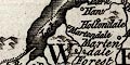
mines
coal mines lead mines |
On Stainmoor are:-
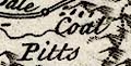
Coal Pitts South of Milburn Forest are:- Lead Mines |
|
Lakes Guides menu.