 Black 1850 map

|

|
|

|
back to object record | |
| Map Features | ||
|
|
||
|
title
map maker engraver publisher |
Printed upper left:-
LANCASTER & CARLISLE RAILWAY AND Adjacent Country Printed at the bottom centre and right:- Published by Adam & Charles Black 27 North Bridge Edinburgh / Drawn & Engraved by J. Bartholomew Edinr. |
|
|
|
||
|
orientation
north point up is E |
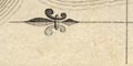
Printed lower right is a north point; N-S line, E-W cross line, North marker by a fleur de lys. The map is printed with East at the top of the sheet; the railway is presented Carlisle to Lancaster, left to right. |
|
|
|
||
|
scale line
scale |
Printed above a scale line upper left is:-
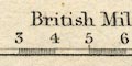
British Miles The scale line is chequered and labelled in miles. The 10 miles = 33.1 mm gives a scale 1 to 486207. The map scale is about:- 1 to 490000 7.5 miles to 1 inch |
|
|
|
||
|
sea area
sea plain |
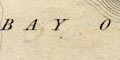
The sea area is plain. Two areas are labelled:- SOLWAY FIRTH BAY OF MORECAMBE |
|
|
|
||
|
coast line
coast form lines foreshore sands sands harbours |
The coast line is emphasised by form lines. Foreshore sands are not marked but might be labelled, eg:- Lancaster Sands Much of the Cumbria coast is cut off by the map border; only one harbour is noticed:- Piel Pier at the end of a railway line from Broughton-in-Furness |
|
|
|
||
|
rivers
bridges |
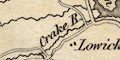
Rivers are drawn by a wiggly line tapering upstream. Some rivers are labelled, in their estuary or alongside the stream, eg:- R. Lune R. Kent Caldew R. Bridges are implied where a road crosses and interrupts a stream. Few are labelled, eg:- Eamont Br. |
|
|
|
||
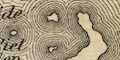
| lakes |
Lakes are drawn in outline with form lines. Some lakes are labelled:- Bassenthwaite W Buttermere Wr. Coniston Wr. Crummock Wr. Derwent W. Devoke Wr. Easthwaite Wr. Ennerdale Water Grasmere Lake Hawes Wr. Lily Tarn Lowes W. Rydal Water Sunbiggin Tarn Thirl Mere Tindal Tarn Ulles Water Wadling Tarn Wast Wr. Windermere Other might be recognized, some doubtfully, eg:- Beacon Tarn Blea Tarn, Borrowdale Blea Water Bleaberry Tarn Blelham Tarn Bowscale Tarn Brothers Water Burnmoor Tarn Cardurnock Lough Codale Tarn decoy pond, Lowther Easedale Tarn Floutern Tarn Goat's Water Greendale Tarn Greycrag Tarn Grisedale Tarn Gurnal Dubs Helton Tarn Kentmere Tarn Keppelcove Tarn Levers Water Little Tarn Low Tarn Low Water Monkhill Lough Out Dubs Tarn Over Water Potter Tarn Red Tarn, Patterdale Scales Tarn Scoat Tarn Seathwaite Tarn Skeggles Water Stickle Tarn Talkin Tarn Tarnhouse Tarn Thurstonfield Lough unidentified tarn, Wreay Urswick Tarn Watendlath Tarn Wythburn Head Tarns |
|
|
|
||
|
relief
hill hachuring |
Relief is indicated by hill hachuring. In some places
this fairly successfully shows a complete range of mountains
and summits, for example the Skiddaw and Saddlebck group.
Also notice the ridges either side of Helvellyn where the
county boundary runs. Some hills are labelled, eg:-
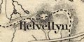
Helvellyn Gt. Dodd Borrowdale Fells Some valleys are labelled, eg:- Borrowdale Eskdale usually along a stream, and not defined by surrounding hachures. |
|
|
|
||
| forests |
Woodland is mostly ignored, but see:-
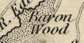
Baron Wood the area pecked. Some forests are labelled, eg:- Inglewood Forest Sleddale Forest |
|
|
|
||
| parks |
Some parks are drawn in outline, the interior pecked,
labelled, eg:-
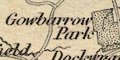
Gowbarrow Park or by the name of the great house, eg:- Conishead Priory |
|
|
|
||
| county |
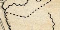
County boundaries are a dashed line, continued alongside a boundary feature by a dotted line. The areas labelled, eg:- WESTMORLAND CUMBERLAND |
|
|
|
||
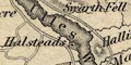
| settlements |
Settlements are marked by blocks, differentiated by style
of labelling.
|
|
| cities |
group of blocks; labelled in san serif upright block
caps, eg:-
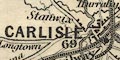
CARLISLE Note that Lancaster is labelled as a city, though without a cathedral. |
|
| towns |
group of blocks; labelled in seriffed upright block caps,
or in upright lowercase text, eg:-
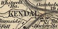
KENDAL APPLEBY PENRITH Shap Ireby |
|
|
villages
hamlets |
block or block; labelled in italic lowercase text,
eg:-
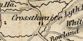
Crossthwaite Reagill This style of lettering is used generally for map features, including houses, castles, etc. |
|
|
|
||
| roads |
A network of roads is drawn by double lines; some roads are narrower, some have light bold lines, perhaps to indicate that they are turnpiked. Some of the narrow roads might be no more than tracks. A few of the roads, at the edge of the map, are labelled with a destination, eg:- From Whitehaven [near Bootle] Fr. Gretna [NW of Carlisle] |
|
|
|
||
| sands roads |
Roads across the sands are drawn by a single dotted line. from Hest Bank across Lancaster Sands to Kents Bank from near Cark across Leven Sands to canal foot, Ulverston. |
|
|
|
||
| railways |
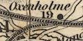
Railways are drawn by a quadruple line, with cross ties between the middle two lines. The line is labelled with the name of the railway. Stations are marked by a dot beside the line. On the Lancaster and Carlisle line the distances from Lancaster are given by the station, eg:- Low Gill / 27 1/2 The railways shown are:- |
|
| Lancaster and Carlisle Railway |
from Lancaster through stations at Hest Bank, Bolton,
Carnforth 6 1/2, Lancashire; then Holme 10 3/4, Milnthorpe
13 1/2, Oxenholme 19, Grayrigg, Low Gill 27 1/2, Tebay 32,
Shap 39 1/2, Clifton 47, Westmorland; then Penrith 51 1/2,
Plumpton 56, Southwaite 62, Brisco 66, to Carlisle 69,
Cumberland.
This line is labelled only by the map title. |
|
| Kendal and Windermere Railway |
from Kendal through stations at Burneside, Staveley, to
Birthwaite, Westmorland.
Labelled:- Kendal & Windermere Ry. There is no Windermere at the terminus. |
|
| Newcastle and Carlisle Railway |
from the east; no stations marked, to Carlisle,
Cumberland.
Labelled:- Newcastle & Carlisle Raily. |
|
| Caledonian Railway |
from Carlisle northward, Cumberland.
Labelled:- Caledonian Railway |
|
| Maryport and Carlisle Railway |
from Carlisle through stations near Dalston, at
Curthwaite, Wigton, Low Row, Heathfield near Brayton,
Aspatria, and south eastward, Cumberland.
Labelled:- Carlisle Maryport and Whitehaven Railway The MandCR was continued south by the Whitehaven Junction Railway. |
|
| Furness Railway |
A detached line from Broughton-in-Furness, no stations
marked, past Kirkby Ireleth, then Ireleth, Furness Abbey, to
Piel Pier, Lancashire.
Labelled:- |
|
|
Furness Railway
|
||
| North Western Railway |
from Lancaster, no stations marked, through Hornby,
Bentham, Clapham, Lancashire; then Settle etc,
Yorkshire.
Labelled:- North Western Railway |
|
|
|
||
| shipping routes |
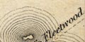
At Piel Pier a dotted line goes SE across the sea, labelled:- To Fleetwood |
|
|
|
||
| canals |
Canals are drawn by a bold curvy line, easy to follow IF you know where the canal runs. The following canals are shown:- |
|
| Lancaster Canal |
from Lancaster to Kendal. Not labelled.
|
|
| Ulverston Canal |
from Ulverston to the Leven Estuary.
|
|
| Carlisle Canal |
from Carlisle to Port Carlisle on the Solway Firth.
Labelled:-
Canal |
|
|
|
||
| miscellaneous | ||
|
|
||
| beacons |
A cairn symbol is labelled:-
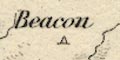
Beacon east of Thackmoor Fell. This is Daffenside Beacon. |
|
|
|
||
| inns |
Inns out of any settlement might be noticed, eg:-
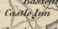
Castle Inn near Bassenthwaite. |
|
|
|
||
|
antiquities
stone circles |
A tumulus symbol (today's style) is labelled:-
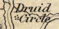
Druids Circle for Castlerigg Stone Circle. |
|
|
|
||
| antiquities |
A ?circle is labelled:-
Arthurs Round Table and nearby is:- Mayborough |
|
Lakes Guides menu.