 Bill 1626

|

|
|

|
back to object record | |
| MAP FEATURES | ||
|
|
||
|
tile cartouche
strapwork cartouche |
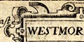
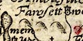
Printed in a strapwork cartouche, upper right:- WESTMOR LAND |
|
|
|
||
|
orientation
up is N |
There is no indicator of orientation except the scales of
latitude and longitude. The map is printed with North at the
top of the sheet.
|
|
|
|
||
|
scale line
scale |
Printed lower right in a strapwork cartouche is:-
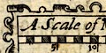
A Scale of Miles chequered in miles, labelled in fives. The 15 miles = 22.7 mm gives a scale 1 to 1063443 wrongly assuming a statute mile. The map scale is about:- 1 to 1100000 ? 17 miles to 1 inch |
|
|
|
||
| lat and long scales |
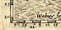
Scales of latitude and longitude are printed in the left and bottom borders, only, for a rectangular projection; chequered and labelled at 5 minute intervals. Notice that longitude is given East of a prime meridian. The longitude, Kendal = 24d 53m E approximately. The prime meridian is about 24d 38m W of Greenwich, roughly in the Cape Verde Islands. The map includes from 20d 50m to 23d 30m E on its prime meridian, ie 1d 08m to 3d 48m W of Greenwich; from 54d 18m to 55d 26m N; all of Westmorland and parts of adjacent counties. |
|
|
|
||
|
sea area
sea moire effect |
The sea area is engraved with a moire effect. |
|
|
|
||
|
coast line
coast shaded foreshore |
The coast line is emphasized by shading. Foreshore sands in the Kent and Leven Estuaries are dotted inside a line outline. |
|
|
|
||
|
rivers
bridges |
Rivers are drawn by a wiggly double line, perhaps broad enough for a stream line, tapering upstream to a single line. No rivers are labelled. On this small map only a few rivers are shown and it is possible to recognize some, eg:- Kent, River Lune, River Eden, River and a few more. The Solway Firth is missing by Carlisle. Notice that Coniston Water does not have an exit river but is drawn more like a sea loch, and Windermere lake only just manages to narrow to a stream to the sea. Two bridges are drawn by a double line crossing and interrupting a stream. Neither is labelled. 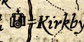
One is the Devil's Bridge at Kirkby Lonsdale, the other probably Levens Bridge. The map does not shew roads. |
|
|
|
||
| lakes |
Lakes are drawn in outline with shore shading. No lake is labelled. It is possible to recognize, not too certainly:- Coniston Water Derwent Water (?) Thirlmere (?) Ullswater Windermere lake |
|
|
|
||
|
relief
hillocks |
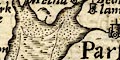
Relief is indicated by hillocks shaded to the east. There is little organisation of the hills; they mostly occur where there is space between labels. Westmorland is hilly. |
|
|
|
||
|
county
swash lettering |
The county boundaries are a fine dotted line which is mostly carried on alongside a boundary feature. The boundary is missing between Westmorland and the south part of Lancashire. Windermere lake seems to be divided by the boundary crossing at the ferry; Ullswater is shown mostly in Cumberland. Adjacent counties are labelled in swash lettering, eg:- PART OF CUMBER LAND |
|
|
|
||
| settlements |
Settlements are mostly marked by a dot and circle or
double circle, with added elements, further differentiated
by style of labelling. Text size is an unreliable guide; all
text is italic.
|
|
| cities |
dot and double circle, towers with crosses; labelled in
larger lowercase italic:-
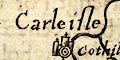
Carleisle |
|
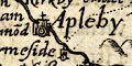
| towns |
dot and double circle, tower with cross; labelled in
larger lowercase italic, eg:-
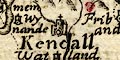
Kendall Apleby |
|
|
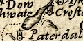
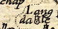
villages
hamlets |
dot and circle, tower; labelled in smaller lowercase
italic, eg:-
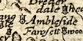
Ambleside Paterdale Brederdale head |
|
| castles |
towers with a flag; labelled in smaller lowercase italic,
eg:-
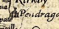
Pendragon castle |
|
| houses |
double circle, tower; labelled in smaller lowercase
italic, eg:-
Berwick Hall [Borwick, Lancashire] |
|
Lakes Guides menu.