 Bacon 1900s B map

|

|
|

|
back to object record | |
| NOTES from BACON'S CYCLING ROAD MAP of ENGLAND AND WALES, 1910s | ||
|
The map size is: wxh, sheet = 53x61.5cm; wxh, map =
512x562mm. Being tightly folded in its road book the map is
badly creased, and is torn from being handled in use. The
paper is thin.
|
||
| Map Features | ||
|
|
||
|
title
map maker |
Printed upper right:-
CYCLING ROAD-MAP OF ENGLAND & WALES Printed at the bottom:- G. W. BACON & CO., Ltd., 127, STRAND, LONDON. |
|
|
|
||
|
orientation
up is N |
The map's orientation is not indicated, except by the
scales of latitude and longitude. The map is printed with
North at the top of the sheet.
|
|
|
|
||
|
scale line
scale |
Printed upper right below the title is a:-
SCALE chequered in miles to 5 then in 10 mile intervals, labelled 0,5,10,20,30,40. The 40 miles = 59.9 mm gives a scale 1 to 1074687. The map scale is about:- 1 to 1000000 17 miles to 1 inch |
|
|
|
||
|
lat and long
lat and long scales |
Printed in the map borders are scales of latitude and
longitude for a trapezoid, or perhaps conical, projection;
chequered at 10 minute intervals, labelled at degrees. The
map includes roughly from 2d E to 6d W, 50.5d to 55.5d N;
England and Wales, the south west peninsular in an insert
upper left, St David's Head etc in an insert on the
left.
|
|
|
|
||
| table of symbols |
Printed upper right below the title is a:-
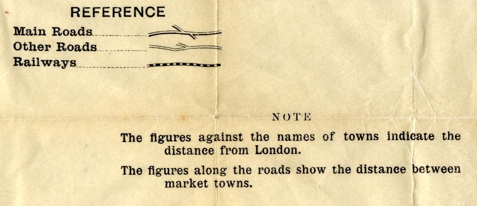
REFERENCE. Main Roads ... [double line, light bold] Other Roads ... [double line, narrower, light light] Railways ... [double line, chequered] NOTE The figures against the names of towns indicate the distance from London. The figures along the roads show the distance between market towns. |
|
|
|
||
|
sea area
sea plain coast line |
The sea area is plain with some areas labelled, eg:-
ENGLISH CHANNEL |
|
|
|
||
| county |
County boundaries are fine dotted lines. County areas are
labelled, eg:-
HAMPSHIRE |
|
|
|
||
|
settlements
distances from London |
Settlements are marked by a few blocks or just a circle;
differentiated by style of labelling.
|
|
| city |
couple of blocks; labelled in upright block caps,
eg:-
WINCHESTER / 62 |
|
| town |
couple of blocks; labelled in upright lowercase text,
eg:-
Stockbridge / 67 The figures are the distances from London. These can be difficult to find amongst all the other figures. |
|
|
village
hamlet |
circle; labelled in italic lowercase text, eg:-
Cadnam The places that are marked and labelled are nodes in the road network. |
|
|
|
||
|
roads
road distances |
Roads are drawn by double line, differentiated by size.
Major roads are broader and have one line bold; minor roads
are narrower.
Distances between market towns are given by figures by the road. Be careful how you read these. |
|
|
|
||
| railways |
Railways are drawn by a chequered double line. Notice
that some stations are used as nodes in the route
itineraries.
Not all railways are shown. |
|
Lakes Guides menu.